


Route: Westweg bis Dobel, Abfahrt nach Bad Herrenalb, Risswasen, Anstieg zur Teufelsmühle
(kurze Schiebepassage), Einkehr, auf der Höhe zur Langmahdskopfhütte, Abfahrt ins Eyachtal, auf dem Enztalradweg zurück nach Niefern.
(kurze Schiebepassage), Einkehr, auf der Höhe zur Langmahdskopfhütte, Abfahrt ins Eyachtal, auf dem Enztalradweg zurück nach Niefern.
Further information at
http://www.biketreff-niefern.deTour gallery
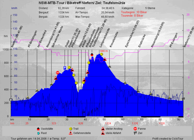
Tour map and elevation profile
Minimum height 232 m
Maximum height 932 m
More about the tour author

|
winklem |
Comments

Martin
on 30.04.2007
Ganz nette Tour mit beim Aufstieg ziemlich heftigen Singeltrial-Passagen vor der Teufelsmühle. Vielleicht wäre die Tour im Uhrzeigersinn besser.
Start in Niefern an der Enz Apotheke.
Mehr Infos unter http://www.biketreff-niefern.de
Mehr Infos unter http://www.biketreff-niefern.de
GPS tracks
Trackpoints-
GPX / Garmin Map Source (gpx) download
-
TCX / Garmin Training Center® (tcx) download
-
CRS / Garmin Training Center® (crs) download
-
Google Earth (kml) download
-
G7ToWin (g7t) download
-
TTQV (trk) download
-
Overlay (ovl) download
-
Fugawi (txt) download
-
Kompass (DAV) Track (tk) download
-
Track data sheet (pdf) download
-
Original file of the author (g7t) download
More about the tour author
|
|
winklem |
Add to my favorites
Remove from my favorites
Edit tags
Open track
My score
Rate