Login

Forgot your login?

Cookies have to be accepted!
Your browser's cookie functionality is disabled. Please enable this functionality.

Not a member yet?

Register now
Login

Available for registred users only

Log in to use this feature.

Forgot your login?

Cookies have to be accepted!
Your browser's cookie functionality is disabled. Please enable this functionality.

Not a member yet?

Register now
Filter
Categories
Advanced filters
  • Distance (km)
  • Height
Save filters Reset filter

TrackRank

QRCode

Technical data

Distance42,1 km Height705 m Way down678 m Duration00:00 h:m Date09.05.2006
Scores Author User Landscape Fun factor Fitness Technique

Statistics

4712 Views 5 Scores 1186 Downloads 3.80 Average
Rate
  • Track data sheet
  • Directions
  • Downloads
Grand Canyon
Montag, 9.30 - 14.30 Uhr, reine Fahrzeit ca. 3,5h
Level 2, 50 km, 600 hm auf, 600 hm
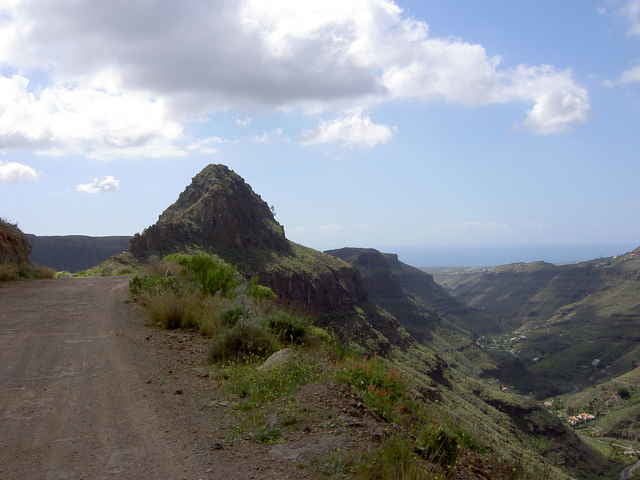
Warmfahrphase im Schilftal von Ayagaures - knackige Offroad-Anstiege zum Adlerpass - sagenhafte Grand Canyon Ausblicke - ruppige Downhills - knüppelharte Waschbrettpiste

Further information at

http://www.free-motion.net/fm/de/tours.php

Tour gallery

Tour map and elevation profile

  • Open Street Map
  • Google
Minimum height -13 m Maximum height 508 m Detailed view

More about the tour author

winklem
Member since 2005

Send private message

Comments

timstruppi on 22.08.2006

Sind 08/2006 diese Tour auch gefahren

Sind diese Tour in unserem Urlaub in Playa del Ingles auch gefahren. Die Strecke in sehr schön.In den Canyons hat man eine tollen Blick richtung Strand.
Landschaftlich und vom Spaßfaktor ist die Strecke wunderbar.
acidtobi on 05.04.2009

empfehlenswerte Tour

Wer's deutlich anspruchsvoller mag fährt die Tour gegen den Uhrzeigersinn, d.h. Anstieg auf besagter "knüppelharter Waschbrettpiste" und den Berg runter auf Schotter und die letzen km sogar auf Straße.
gpsbiker on 08.05.2013

landschaftlich grandios

An unserem letzten Tag sind wir diese Runde gefahren. Alles sehr gut fahrbar, die Anstiege sind alle fahrbar und auch die Waschbrettpisten sind nicht so schlimm. Landschaftlich eine grandiose Canyontour.
martinkochdd on 28.11.2016

CCbike

kann man die Tour mit dem CC-Rad fahren? Wenn ja wohl eher gegen den Uhrzeigersinn dann ist die Abfahrt einfacher oder?
ebikespass on 20.07.2018

Ein Artikel inkl. Video über diese Tour

Ich hatte mir für diese Tour ein E-Bike von freemotion in Playa del Ingles geliehen, ein Haibike SDURO Fullseven 7.0, Modelljahr 2017. Auf diese Weise lernt man Gran Canaria kennen, viel besser als vom Auto ... Hier ein Artikel in meinem Blog inklusive Video: <a href="https://www.ebikespass.de/e-bike-gran-canaria-vulkancanyons/" target="_blank">Mit dem E-Bike in die Vulkancanyons</a>
Start am Free Motion Center in der Avda. de Alfereces Provisionales

GPS tracks

Trackpoints
  • GPX / Garmin Map Source (gpx) download
  • TCX / Garmin Training Center® (tcx) download
  • CRS / Garmin Training Center® (crs) download
  • Google Earth (kml) download
  • G7ToWin (g7t) download
  • TTQV (trk) download
  • Overlay (ovl) download
  • Fugawi (txt) download
  • Kompass (DAV) Track (tk) download
  • Track data sheet (pdf) download
  • Original file of the author (g7t) download

More about the tour author

winklem
Member since 2005

Send private message
Share track
Add to my favorites
Remove from my favorites
Edit tags
My score
Rate
Track: Gran Canaria Tour Grand Canyon mit FreeMotion
Type: Mountain bike
Distance: 42,1 km
Evaluated on:
Duration:
Day(s)
Hour(s)
Minute(s)
Score: Landscape Fun factor Fitness Technique