Login

Forgot your login?

Cookies have to be accepted!
Your browser's cookie functionality is disabled. Please enable this functionality.

Not a member yet?

Register now
Login

Available for registred users only

Log in to use this feature.

Forgot your login?

Cookies have to be accepted!
Your browser's cookie functionality is disabled. Please enable this functionality.

Not a member yet?

Register now
Filter
Categories
Advanced filters
  • Distance (km)
  • Height
Save filters Reset filter

TrackRank

QRCode

Technical data

Distance44,2 km Height398 m Way down483 m Duration03:15 h:m Date15.06.2009
Scores Author Landscape Fun factor Fitness Technique

Statistics

2196 Views Scores 188 Downloads Average
Rate
  • Track data sheet
  • Directions
  • Downloads
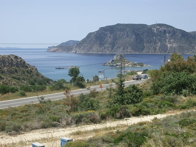
Da Kos eine sehr kleine und flache Insel ist liegt der Versuch nahe, eine Entdeckungsreise mit dem Rad. Die Runde startet in Mastichari und führt entlang der Nordküste bis kurz vor Stefanos alles auf Schotterwegen. Mit einem Tourenbike ist das befahren eigentlich problemlos, mit dem Rennrad ist es unmöglich. Dieser Streckenabschnitt führt entlang der einsamsten Ständen im Norden in einer wunderschönen leicht hügeligen Landschaft. Ab Stefanos führt die Strecke weiter auf Asphalt nach Kefalos. Hier sollte man sich auf jeden Fall Zeit für eine Rast nehmen und das Städchen besichtigen ehe es wieder auf den Heimweg, vorbei an der wunderschönen Bucht von Kamari und weiter auf dem Höhenrücken in Richtung Antimacheia geht. Nach Antimacheia geht es nur mehr bergab bis Mastichari, Im Gepäck sollte man auf jeden Fall genug Wasser und die Badehose haben! Für Konditionsstarke Radfahrer ist ein Abstecher oder Rundenerweiterung nach Kardamenia und Pyli empfehlenswert.

Further information at

http://www.bike-4-fun.at

Tour gallery

Tour map and elevation profile

  • Open Street Map
  • Google
Minimum height 103 m Maximum height 994 m Detailed view

More about the tour author

franz.resch
Member since 2006

Send private message

Comments

Mastichari ist leicht mit dem öffentlichen Bus und auch mit dem Fahrrad erreichbar.

GPS tracks

Trackpoints
  • GPX / Garmin Map Source (gpx) download
  • TCX / Garmin Training Center® (tcx) download
  • CRS / Garmin Training Center® (crs) download
  • Google Earth (kml) download
  • G7ToWin (g7t) download
  • TTQV (trk) download
  • Overlay (ovl) download
  • Fugawi (txt) download
  • Kompass (DAV) Track (tk) download
  • Track data sheet (pdf) download
  • Original file of the author (gpx) download

More about the tour author

franz.resch
Member since 2006

Send private message
Share track
Add to my favorites
Remove from my favorites
Edit tags
My score
Rate
Track: Mit dem Rad von Mastichari nach Kefalos
Type: Bicycle tours
Distance: 44,2 km
Evaluated on:
Duration:
Day(s)
Hour(s)
Minute(s)
Score: Landscape Fun factor Fitness Technique