


Start in Gerlingen in der Waldsiedlung ins Krummbachtal, Madental, Büsnau, Katzenbacherhof, Glemseck, Eltingen, Leonberg, Hinterer Ehrenberg, Schillerhöhe, Solitude, Botnang, Burg Dischingen zum Lemberg, Lindental, Solitude, Schillerhöhe,und zurück.
Die Tour kann aber auch beim Lemberg, Solitude, Büsnau, Leonberg, Katzenbacherhof, etc. begonnen werden.
Die Tour kann aber auch beim Lemberg, Solitude, Büsnau, Leonberg, Katzenbacherhof, etc. begonnen werden.
Further information at
http://www.biketreff-niefern.deTour gallery
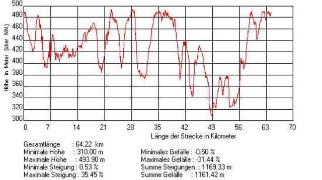
Tour map and elevation profile
Minimum height 190 m
Maximum height 507 m
More about the tour author

|
winklem |
Comments

Start in Gerlingen in der Waldsiedlung
GPS tracks
Trackpoints-
GPX / Garmin Map Source (gpx) download
-
TCX / Garmin Training Center® (tcx) download
-
CRS / Garmin Training Center® (crs) download
-
Google Earth (kml) download
-
G7ToWin (g7t) download
-
TTQV (trk) download
-
Overlay (ovl) download
-
Fugawi (txt) download
-
Kompass (DAV) Track (tk) download
-
Track data sheet (pdf) download
-
Original file of the author (g7t) download
More about the tour author
|
|
winklem |
Add to my favorites
Remove from my favorites
Edit tags
Open track
My score
Rate