Login

Forgot your login?

Cookies have to be accepted!
Your browser's cookie functionality is disabled. Please enable this functionality.

Not a member yet?

Register now
Login

Available for registred users only

Log in to use this feature.

Forgot your login?

Cookies have to be accepted!
Your browser's cookie functionality is disabled. Please enable this functionality.

Not a member yet?

Register now
Filter
Categories
Advanced filters
  • Distance (km)
  • Height
Save filters Reset filter

TrackRank

QRCode

Technical data

Distance76,6 km Height1093 m Way down1094 m Duration04:00 h:m Date29.06.2009
Scores Author Landscape Fun factor Fitness Technique

Statistics

502 Views 1 Score 71 Downloads 4.00 Average
Rate
  • Track data sheet
  • Directions
  • Downloads

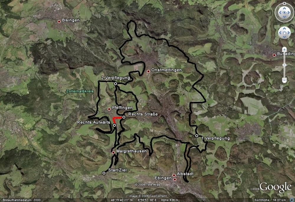
Für alle die, diese CTF-Runde des Freestyle-Club Zollernalb verpaßt haben.

Start und Ziel befindet sich an der Sporthalle von Albstadt-Lautlingen.

Von dort verläuft der Track (Fitness-Tour 75km) zum größten Teil auf Schotter und Teer rund um die Stadtteile: Lautlingen, Margrethausen, Truchtelfingen, Ebingen, Onstmettingen, Pfeffingen und Tailfingen.

Da die Runde wie eine Acht angelegt ist, fährt man einen Teil der Strecke doppelt (von Pfeffingen bis nach Margrethausen). Wer das Teilstück nicht zweimal fahren will, kann auch die L442 nach Pfeffingen hinunter und an der Gabelung links Richtung Margrethausen (K7151) fahren. Nach 500m biegt man rechts in den Heimbolweg (Farbrik Schneider Sportwear) und somit wieder in den Track ein.


Further information at

http://www.freestyleski.de/index2.htm

Tour map and elevation profile

  • Open Street Map
  • Google
Minimum height 668 m Maximum height 934 m Detailed view

More about the tour author

MisterBlubb
Member since 2007

Send private message

Comments

bujo12 on 03.07.2009

CTF 2009

Der CTF- Event macht sehr viel spaß!

Unbedingt mitmachen!

GPS tracks

Trackpoints
  • GPX / Garmin Map Source (gpx) download
  • TCX / Garmin Training Center® (tcx) download
  • CRS / Garmin Training Center® (crs) download
  • Google Earth (kml) download
  • G7ToWin (g7t) download
  • TTQV (trk) download
  • Overlay (ovl) download
  • Fugawi (txt) download
  • Kompass (DAV) Track (tk) download
  • Track data sheet (pdf) download
  • Original file of the author (gpx) download

More about the tour author

MisterBlubb
Member since 2007

Send private message
Share track
Add to my favorites
Remove from my favorites
Edit tags
My score
Rate
Track: CTF-Freestyle-Club Zollernalb 2009
Type: Mountain bike
Distance: 76,6 km
Evaluated on:
Duration:
Day(s)
Hour(s)
Minute(s)
Score: Landscape Fun factor Fitness Technique