


Spur des Trenga MTB-Marathons mit Start am Landesleistungszentrum Biathlon im Zellerfelder Tal.
Bis auf ca. 6km Strasse führt die Strecke zu einem größeren Teil über Schotterwege mit z.T. längeren Abfahrten. Die übrigen Streckenabschnitte sind abwechselungsreich von schmalen, mitunter steilen Trails bis hin zu "bequemen" Überquerungen der gn. Wiese. Insgesamt eine sehr schöne, zugleich aber auch recht anspruchsvolle Runde. Kurz nach dem Start (KM5), sowie bei KM30 sind zwei recht steile Abfahrten zu nehmen. Die erste führt über einen zerklüfteten Stein-/Schotterweg, die zweite einen schmalen Trail im teilweise dichten Wald herunter. Im Anschluss an die zweite Abfahrt folgt ein ähnlicher steiler Anstieg, der sich allenfalls teilweise fahren läßt.
Bis auf ca. 6km Strasse führt die Strecke zu einem größeren Teil über Schotterwege mit z.T. längeren Abfahrten. Die übrigen Streckenabschnitte sind abwechselungsreich von schmalen, mitunter steilen Trails bis hin zu "bequemen" Überquerungen der gn. Wiese. Insgesamt eine sehr schöne, zugleich aber auch recht anspruchsvolle Runde. Kurz nach dem Start (KM5), sowie bei KM30 sind zwei recht steile Abfahrten zu nehmen. Die erste führt über einen zerklüfteten Stein-/Schotterweg, die zweite einen schmalen Trail im teilweise dichten Wald herunter. Im Anschluss an die zweite Abfahrt folgt ein ähnlicher steiler Anstieg, der sich allenfalls teilweise fahren läßt.
Further information at
http://www.wsv.harz.de/radsport/Marathon/marathon.htmTour gallery
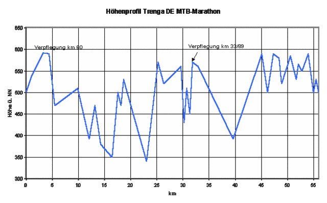
Tour map and elevation profile
Minimum height 359 m
Maximum height 597 m
More about the tour author

|
Comments

Anfahrt erfolgt vorzugsweise über die B242, d.h. zumindest von Westen kommend zuvor über die A7. Ca. 3km vor Clausthal biegt links eine Art Umgehungsstrasse nach Zellerfeld ab. Dieser folgen wobei sich nach etwa 1km auf der linken Seite das LLZ mit zugehörigem Parkplatz befindet.
GPS tracks
Trackpoints-
GPX / Garmin Map Source (gpx) download
-
TCX / Garmin Training Center® (tcx) download
-
CRS / Garmin Training Center® (crs) download
-
Google Earth (kml) download
-
G7ToWin (g7t) download
-
TTQV (trk) download
-
Overlay (ovl) download
-
Fugawi (txt) download
-
Kompass (DAV) Track (tk) download
-
Track data sheet (pdf) download
-
Original file of the author (g7t) download
More about the tour author
|
|
Add to my favorites
Remove from my favorites
Edit tags
Open track
My score
Rate