


N° 1 SALO’ –SANICO- TOSCOLANOMADERNO.
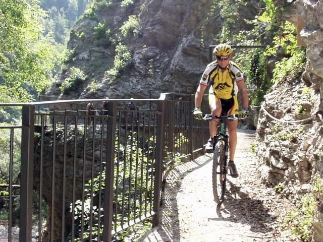
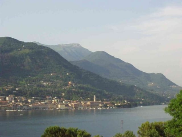
Questo itinerario è tra i più belli della sponda bresciana. L’intero percorso è costantemente fronte lago e lascio a voi immaginare lo spettacolo che andrete a vedere. Esso si sviluppa tra i comuni di Salò e Toscolano Maderno. Con un variare di altitudine che va dai 65 ai 350 metri sul livello del mare. Uno degli aspetti che caratterizzano questo itinerario è sicuramente la natura che lo avvolge. Passando tra boschi, vallate ed uliveti, attraversando fiumi e torrenti. Durante il percorso ci si accorge di come la conformazione naturale del Garda Bresciano sia suggestiva, ricca di contrasti e colori, intrecciandosi in un unico spettacolo. Durante il percorso si scoprono realtà locali caratteristiche come paesini e borghi che, con i loro colori e profumi rendono incantevole la giornata. E perché no uno spunto in più per ritornarci con tutta la famiglia. Volendo non manca l’occasione di aumentare la vostra cultura generale, con una visita guidata al “Museo della carta” nella valle delle Cartiere. Per riscoprire i metodi e le tecniche di una delle valli più importanti per la produzione della carta tra il 1381 a 1960. Altro luogo storico-culturale che troviamo all’interno del nostro itinerario è senz’altro il “Vittoriale degli Italiani” casa di uno dei personaggi più rappresentativi d’Italia Gabriele D’Annunzio. Anche qui vi è la possibilità di una visita guidata. Durante il percorso non manca la voglia di fermarsi in qualche agriturismo per riposarsi ed assaggiare i prodotti locali. Considerando l’aspetto tecnico, ritengo l’intero percorso adatto alla maggior parte dei bikers. Sconsigliato per famiglie con bimbi piccoli. Si tratta pur sempre di un percorso per mtb con salite e discese anche se brevi ma con fondo sterrato.
N° 1 SALO’ –SANICO- TOSCOLANOMADERNO. English
This route is one of the most beautiful side Bresciana. The entire route is constantly facing the lake and leave it to you imagine that the show will go to see. It develops between the municipalities of Salò and Toscolano Maderno. With a change of altitude ranging from 65 to 350 metres above sea level. One of the features of this journey is surely the nature that surrounds him. Passing through woods, valleys and olive groves, crossing rivers and streams. During the path we can see how the conformation natural of the Garda Bresciano is evocative, full of contrasts and colors, mixsed in a single show. During the tour discover local characteristics as towns and villages, with their colors and fragrances make enchanting the day. And why not one more opportunity to come back for the entire family. Wanting not missing an opportunity to increase your general culture, with a guided tour of the Museum Paper "in the valley of Cartiere. To rediscover the methods and techniques of one of the valleys most important for the production of paper from 1381 to 1960. Other historical-cultural place we find in our itinerary is the "Vittoriale of Italians" house of one of the most representative of Italy Gabriele D'Annunzio. Again, there is the possibility of a guided tour. During the path does not lack the will to stop somewhere farmhouse to relax and taste local products. Considering the technical aspect, I think the whole path suited to most bikers. Not recommended for families with small children. This is still a path for mtb with climbs and descents although with a short but dirt.
Ps. Sorry for my english
Tour Galerie
Tour Karte und Höhenprofil
Minimale Höhe 75 m
Maximale Höhe 348 m
Mehr zum Tourautor
|
|
ugo-mtb |
Kommentare

GPS-Tracks
Trackpunkte-
GPX / Garmin Map Source (gpx) download
-
TCX / Garmin Training Center® (tcx) download
-
CRS / Garmin Training Center® (crs) download
-
Google Earth (kml) download
-
G7ToWin (g7t) download
-
TTQV (trk) download
-
Overlay (ovl) download
-
Fugawi (txt) download
-
Kompass (DAV) Track (tk) download
-
Tourenblatt (pdf) download
-
Originaldatei des Autors (gpx) download
Mehr zum Tourautor
|
|
ugo-mtb |
Zu meinen Favoriten hinzufügen
Von meinen Favoriten entfernen
Tags bearbeiten
Tour öffnen
Meine Bewertung
Bewerten