


Top of Malaysia - Pahang's high 4 - or call it Malaysia extreme...
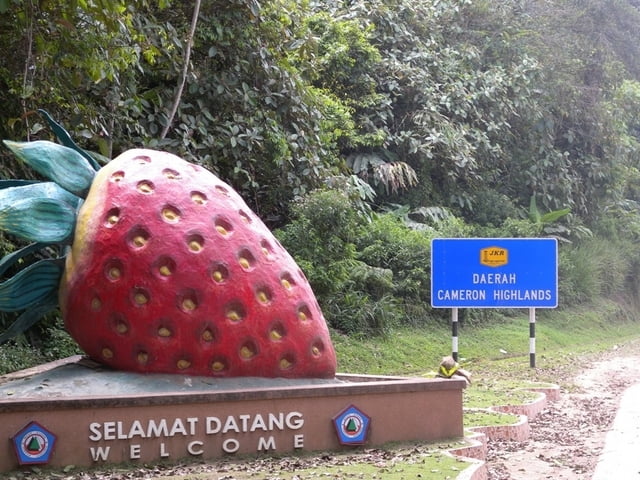
This tour brings you onto the highest places you can get on a road by a (non-mountainbke) bicycle along with some cultural and city highlights in Malaysia. Besides enjoying some fresh strawberries in the Cameron Highlands and a cup of excellent tea, be prepared for the heat in the low lands and heavy traffic in Kuala Lumpur.
I have cycled on an ordinary road (race) bike without any adjustments and with extremely light bagagge. My whole luggage was of around 3kg. You do not need much of clothing nor food as you can get good and cheap food and drinks anywhere along the route as well as very cheap accommodation. ...and besides a second pair of shorts, a T-shirt a pair of flip flops will do the job as the temperatures are in the mid- to high-20's also at night.
The first leg (Melaka to Kuala Lumpur) is of ~170km, not very spectacular but gives you a good feeling of the traffic outside and inside the cities. In Melaka you can visit the historic sites from the Portuguese and Dutch eras, whereas in Kuala Lumpur you'd more go for the modern big city life and architecture. ...And try to enjoy the KL traffic. It's not as bad as it may seem on the first sight.
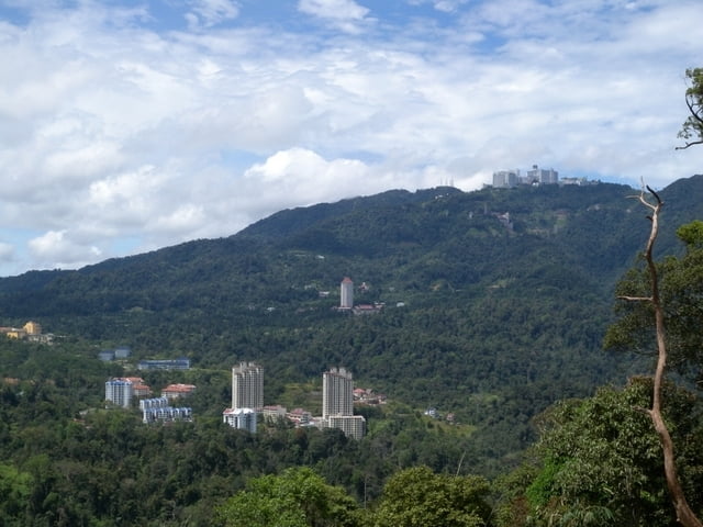
The second leg from Kuala Lumpur to Bentong gives you the first mountain kick - and you'd have the opportunity to legaly(!) cycle on a highway. From Gombak you can cycle up to the pass below Genting on the old road (nr 68) but then to the Genting City at the summit, there is only the big one available. From the 68 carry the bike over to the other side of the road, that will give you the possibility to cycle up immediately. A legal - but more streneous way - would be to cycle down about one km and then U-turn at a petrol station; but you have to go back the km on a 10% incline... Make sure you attempt to cycle up on a weekday as on the weekends the traffic is really heavy. Genting is Malaysia's Las Vegas, so you can imagine what's going on there on Saturdays and Sundays.
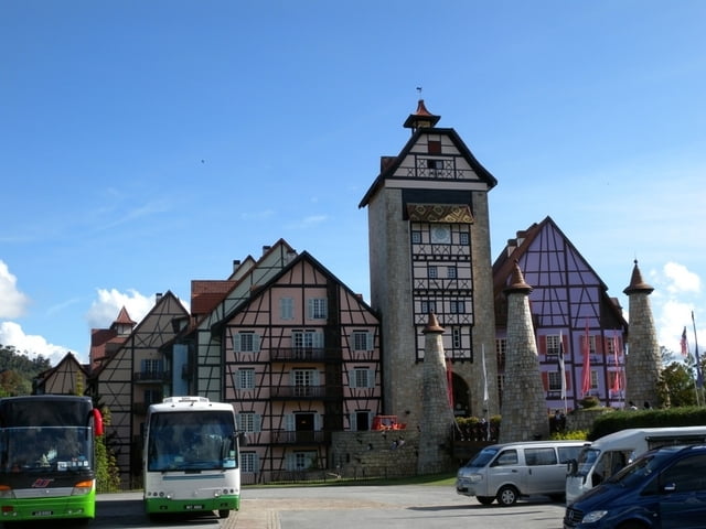
Going down from Genting back to the lowlands you can either stay on the highway (but only if you do not go back to KL) or can take the nice nr 68. But take the decision for the road wisely and only once you've decided whether you want to cycle up the Berjaya Hills resort with some French/Alsas castles and houeses (Colmar Tropicale) and/or enjoy a Japanese Tea garden. The access to the Resort is as to Genting only from the Highway, so you have to go there - of you carry up your bike some 20 meters through the forrest, onto Berjaya Hills exit of the highway. Well and then just enjoy the rest... and let me know, whether you've cycled up the last bit of the road to the Japanese Tea Garden or you had to push... It's some >20% incline and I almost fell backwards from my bike when going up.
The downhill is then all the way to Bentong, so after all the work is done you have the fun for some 30km... Overall length ~120km.
The third leg takes you on the old Nr 8 through a lot of plantations and if you like durian (the king of fruits but not everyone likes the smell) then this is the place to be. There are a lots of durian plantations and you can get it anywhere around. The old Nr 8 is a nice road with very low traffic and you stay on there for some 30km until you reach the junction towards Bukit Fraser/Fraser Hill. From there it's another 30km (!) uphill towards the summit, on the other hand, you'll enjoy another 40km downhill when going down to the Perak's side of the mountain range (Kota Kaba Baru). From there it's a nice ride towards Proton City (that's where the Malaysian Nr.1 cars are produced) and Kampung Slim, just an outskirt Kampung of the town Slim River. There is not much in Slim River but you can sleep, eat and if you like you can even take a train from there to Ipoh and/or Kuala Lumpur. Should you be into MTB and some hiking, in the hoods there are plenty of nice trails... Length ~150km.
The fourth (and fifth) leg is rather a test of your mental than physical strengh. From Slim River you cycle on the Nr 1 towards Tapah, some 45km to get warmed up properly before the fun starts. From Tapah it's about 70km(!) constantly uphill until you reach the main town of Cameron Highlands (Brinchang). The road conditions are generally very good, even the road is quite narrow. The incline is low, so you'll be able to keep a very nice rhythm the whole way up. Here you also need to make sure not to cycle up during a weekend, when the traffic is very heavy. Round up your day with a pack of freshly grown local strawberries. If you still did not have enough for the day, you can attempt to attack the summit of Gunung Brinchang (2032m) which is the highest place in (Western) Malaysia that you can go up by a bike (or an ordinary car). But make sure you really have enough stamina left. The 9km road uses 4km for a flat/downhill section which leaves some 700m to be climbed over 5km. You do the math on the average incline... Length ~110km (without the summit)
The fifth leg starts early in the morning going up to the summit (take the cool period of the day for the climb, and wait until it gets warm for the downhill). Enjoy the view and get back down to Brinchang to get ready for the rest of the day. This will bring you down from 2000m back to some 100m elevation at Gua Musang. Should you have not gone crazy on the climb yesterday, that today will definitely be the ultimate mental test. Evn thou you are supposed to LOOSE almost 2000m of altitude, at the end of the day my altimeter have shown 1500m of ascent (without the summit!)! The portion of the "new road" of some 100km is very very hilly. The first 20-25km are a pretty nice almost straight down downhill but the remaining 50km until you reach the D30 has endless rolling hills. They are all quite steep and long and the loss of altitude is very slow.
My final - sixth - day was not intented to be a cycling day but as all the long distance busses were sold out I had to take a ride on the bike and try to catch a lorry towards the south to get back to Melaka... The leg is not very spectacular. Sunday morning was a good time to cycle there as the traffic was still low. The nr 8 is the main road in this area and accommodates usually heavy traffic. Only in the afternoon the traffic was getting more and more. Expect again a lot of rolling hills, but not as nasty as "yesterday". About 5km behind the section where my track record ends, a steep (10%) and long (~5km) hill comes into the picture. I was fortunate enough to get a lorry ride at this point that took me all the way down to KL to catch a bus further south... Length ~53km.
The track attached here has been optimized and all the detours etc what I did has been taken out. The optimal route would be of some 720km but adding some detours, searches for accommodation, food, cycling around KL, etc it summs up to more than 800km.
For all those who would like to continue cycling, from Gua Musang you can choose to cycle to the North (Jeli) and from there back to the West (Penang) or you take the new Eastern route to Kuala Terengganu that passes by the beatiful Lake Kenyir. While Jeli certainly can be reached within one day, Kuala Terengganu will be rather approached over 2 days.
Tour Galerie
Tour Karte und Höhenprofil
Minimale Höhe 10 m
Maximale Höhe 2027 m
Mehr zum Tourautor
|
|
mblanarik |
Kommentare

Mehr zum Tourautor
|
|
mblanarik |
Zu meinen Favoriten hinzufügen
Von meinen Favoriten entfernen
Tags bearbeiten
Tour öffnen
Meine Bewertung
Bewerten