Login

Forgot your login?

Cookies have to be accepted!
Your browser's cookie functionality is disabled. Please enable this functionality.

Not a member yet?

Register now
Login

Available for registred users only

Log in to use this feature.

Forgot your login?

Cookies have to be accepted!
Your browser's cookie functionality is disabled. Please enable this functionality.

Not a member yet?

Register now
Filter
Categories
Advanced filters
  • Distance (km)
  • Height
Save filters Reset filter

TrackRank

QRCode

Technical data

Distance11,3 km Height529 m Way down505 m Duration03:15 h:m Date14.07.2012
Scores Author Landscape Fun factor Fitness Technique

Statistics

329 Views Scores 16 Downloads Average
Rate
  • Track data sheet
  • Directions
  • Downloads

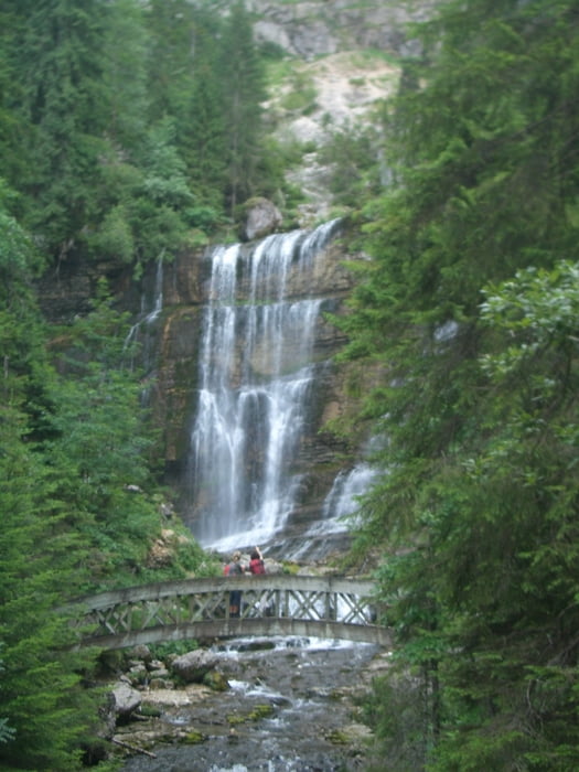
Schöne Wanderung durch Wald und Dörfchen mit gesicherter Kletterei und Höhlenabenteuer rund um einen Wasserfall.

Die Wanderung folgte der Tour 41 im Rother Wanderführer "Savoyen" von R. Scholl (1. Aufl. 2006).

Tour gallery

Tour map and elevation profile

  • Open Street Map
  • Google
Minimum height 640 m Maximum height 1161 m Detailed view

More about the tour author

Binuschka
Member since 2012

Send private message

Comments

Start- und Zielpunkt war in St. Pierre d'Entremont.

GPS tracks

Trackpoints
  • GPX / Garmin Map Source (gpx) download
  • TCX / Garmin Training Center® (tcx) download
  • CRS / Garmin Training Center® (crs) download
  • Google Earth (kml) download
  • G7ToWin (g7t) download
  • TTQV (trk) download
  • Overlay (ovl) download
  • Fugawi (txt) download
  • Kompass (DAV) Track (tk) download
  • Track data sheet (pdf) download
  • Original file of the author (gpx) download

More about the tour author

Binuschka
Member since 2012

Send private message
Share track
Add to my favorites
Remove from my favorites
Edit tags
My score
Rate
Track: Wanderung zu den Wasserspielen oberhalb Le Cirque de Saint-Même
Type: Mountain hiking
Distance: 11,3 km
Evaluated on:
Duration:
Day(s)
Hour(s)
Minute(s)
Score: Landscape Fun factor Fitness Technique