

Meine Strecke
Start und Ziel:
Parkplatz am VW-Bad in Wolfsburg,
wir fahren links am
VW-Bad im Stadtwald lang.
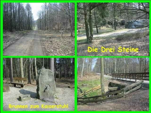
Nachdem wir ein paar Minuten
auf dem Hauptweg gefahren sind,
liegt links eine kleine Erfrischung
„Brunnen zum Kaiserstuhl“
damit können wir unsere Wasserflaschen
auffüllen – schmeckt lecker.
Wir haben von den Brunnen und Quellen
noch mehr bei uns im Wald.
Also verdursten wird man nicht,
weiter geht’s Richtung Barnstorf,
durch den Barnstorfer Wald wo wir wieder
nachher zurückkommen
und in Richtung VW-Bad
wieder ans Ziel kommen.
weitere Touren hier in Wolfsburg und Umgebung
liegen auf meiner Homepage
www.wolfsburg-gps-tour.de
viel Spaß beim nachfahren
Further information at
http://www.wolfsburg-gps-tour.deTour gallery
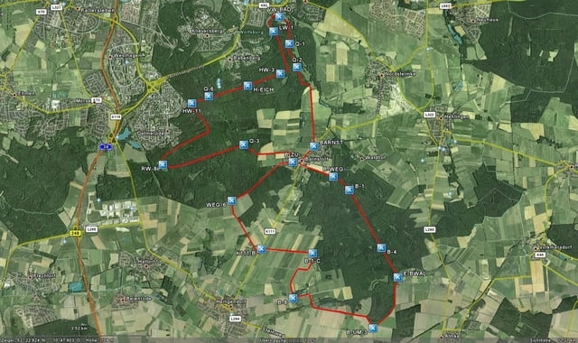
Tour map and elevation profile
Minimum height 99999 m
Maximum height 2147483647 m
More about the tour author
|
|
KlausWob |
Comments

gegenüber vom Großen Schiller Teich
Berliner Ring beim Porsche Stadion
Parkplatz am VW-Bad
Berliner Ring beim Porsche Stadion
Parkplatz am VW-Bad
GPS tracks
Trackpoints-
GPX / Garmin Map Source (gpx) download
-
TCX / Garmin Training Center® (tcx) download
-
CRS / Garmin Training Center® (crs) download
-
Google Earth (kml) download
-
G7ToWin (g7t) download
-
TTQV (trk) download
-
Overlay (ovl) download
-
Fugawi (txt) download
-
Kompass (DAV) Track (tk) download
-
Track data sheet (pdf) download
-
Original file of the author (g7t) download
More about the tour author
|
|
KlausWob |
Add to my favorites
Remove from my favorites
Edit tags
Open track
My score
Rate