Login

Forgotten password?

Cookies have to be accepted!
Your browser's cookie functionality is disabled. Please enable this functionality.

Not a member yet?

Register now
Login

Available for registred users only

Log in to use this feature.

Forgotten password?

Cookies have to be accepted!
Your browser's cookie functionality is disabled. Please enable this functionality.

Not a member yet?

Register now
Filter
Categories
Advanced filters
  • Distance (km)
  • Height
Save filters Reset filter

TrackRank

QRCode

Technical data

Distance14,5 km Height1150 m Way down1144 m Duration03:15 h:m Date13.01.2013
Scores Author Landscape Fun factor Fitness Technique

Statistics

481 Views Scores 68 Downloads Average
Rate
  • Track data sheet
  • Directions
  • Downloads
Von der Schönangeralm Richtung Talschluß locker eingehen, dann über den Kastensteig den ersten Steilen Teil im Wald überwinden. Nachher weiter rechts vom Bach an der Gressensteinalm vorbei in einem langen Rechtsbogen auf den Gipfel.

Tour gallery

Tour map and elevation profile

  • Open Street Map
  • Google
Minimum height 1163 m Maximum height 2318 m Detailed view

More about the tour author

markus-w
Member since 2010

Send private message

Comments

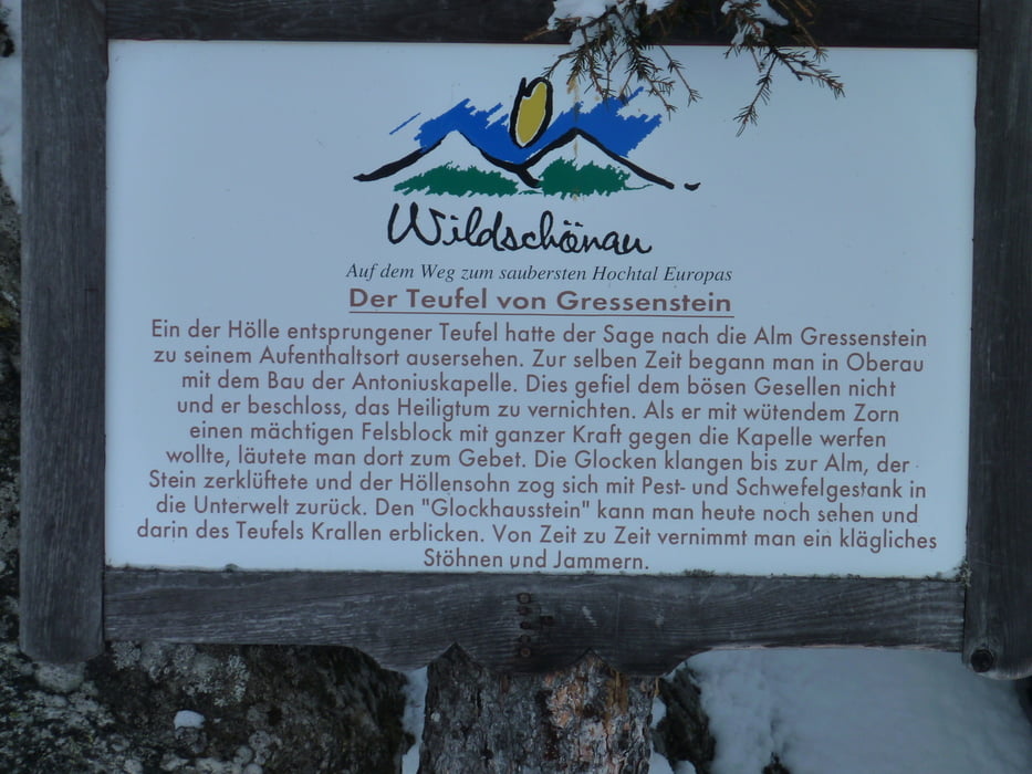
Grenze Kufstein, Ausfahrt Wörgel dann ins Wildchönau Tal fahren

GPS tracks

Trackpoints
  • GPX / Garmin Map Source (gpx) download
  • TCX / Garmin Training Center® (tcx) download
  • CRS / Garmin Training Center® (crs) download
  • Google Earth (kml) download
  • G7ToWin (g7t) download
  • TTQV (trk) download
  • Overlay (ovl) download
  • Fugawi (txt) download
  • Kompass (DAV) Track (tk) download
  • Track data sheet (pdf) download
  • Original file of the author (gpx) download

More about the tour author

markus-w
Member since 2010

Send private message
Share track
Add to my favorites
Remove from my favorites
Edit tags
My score
Rate
Track: Großes Beil 2309m Wildschönau
Type: Ski touring
Distance: 14,5 km
Evaluated on:
Duration:
Day(s)
Hour(s)
Minute(s)
Score: Landscape Fun factor Fitness Technique