Login

Forgot your login?

Cookies have to be accepted!
Your browser's cookie functionality is disabled. Please enable this functionality.

Not a member yet?

Register now
Login

Available for registred users only

Log in to use this feature.

Forgot your login?

Cookies have to be accepted!
Your browser's cookie functionality is disabled. Please enable this functionality.

Not a member yet?

Register now
Filter
Categories
Advanced filters
  • Distance (km)
  • Height
Save filters Reset filter

TrackRank

QRCode

Technical data

Distance22,5 km Height1010 m Way down1010 m Duration02:15 h:m Date27.05.2013
Scores Author Landscape Fun factor Fitness Technique

Statistics

865 Views 1 Score 159 Downloads 4.00 Average
Rate
  • Track data sheet
  • Directions
  • Downloads

Von Stumm im Zillertal (560 m) aus auf den Gattererberg. Max. Höhe 1580 m.

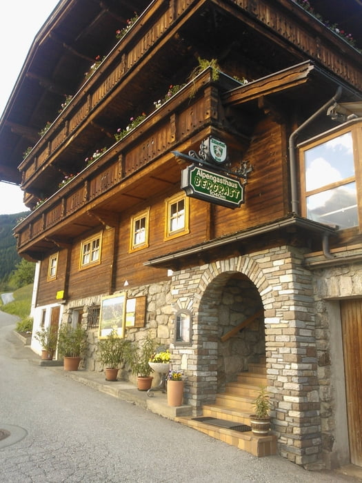
Bis zum Gasthof Bergrast Aufstieg auf Asphalt. Dann, also die obere Hälfte der Tour,  auf Forststrassen über Steinbergaste zum Gasthof Almluft. Ab hier rasante Abfahrt auf Asphalt.

Keine technische aber konditionelle Herausforderung. Vorallem wenn man wie ich das ganze als Nachmittagstour durch fährt.

Bei der Bergrast wollte ich noch nicht einkehren und die Almluft hatte Ende Mai nur am Wochenenden geöffnet. Schade ;-)  Beide Gasthöfe sehen sehr einladend aus.


Tour gallery

Tour map and elevation profile

  • Open Street Map
  • Google
Minimum height 556 m Maximum height 1577 m Detailed view

More about the tour author

hotchillyred
Member since 2010

Send private message

Comments

spoonloop on 05.07.2020

Tour #118019: Stumm Gattererberg

sehr schöne Tour, mit dem E-Bike gefahren. Herrliche Blicke, kein Schieben/Tragen und ein Lokal (Almluft) vor der Abfahrt auf Asphalt.

GPS tracks

Trackpoints
  • GPX / Garmin Map Source (gpx) download
  • TCX / Garmin Training Center® (tcx) download
  • CRS / Garmin Training Center® (crs) download
  • Google Earth (kml) download
  • G7ToWin (g7t) download
  • TTQV (trk) download
  • Overlay (ovl) download
  • Fugawi (txt) download
  • Kompass (DAV) Track (tk) download
  • Track data sheet (pdf) download
  • Original file of the author (gpx) download

More about the tour author

hotchillyred
Member since 2010

Send private message
Share track
Add to my favorites
Remove from my favorites
Edit tags
My score
Rate
Track: Stumm Gattererberg
Type: Mountain bike
Distance: 22,5 km
Evaluated on:
Duration:
Day(s)
Hour(s)
Minute(s)
Score: Landscape Fun factor Fitness Technique