


Bensheim - Hemsberg - Heppenheim - Starkenburg - Jägerrast - Steinschloss - Krehberg - Breitenwiesen - Kolmbach - Kaiserturm - Neuenkirchner Höhe - Gersprenzquelle - Wildweibchenstein - Ruine Rodenstein - Berg Ramdimdim - Gagernstein - Felsenmeer Steinau - Bärlingsquelle - Lützelbach - Modautal - Bedenkirchen - Felsenmeer - Olyturm - Teufelsberg - Ludwigshöhe - Fürstenlager - Ludwigslinde - Wambolder Sand - Kirchberg Häuschen - Bensheim
Further information at
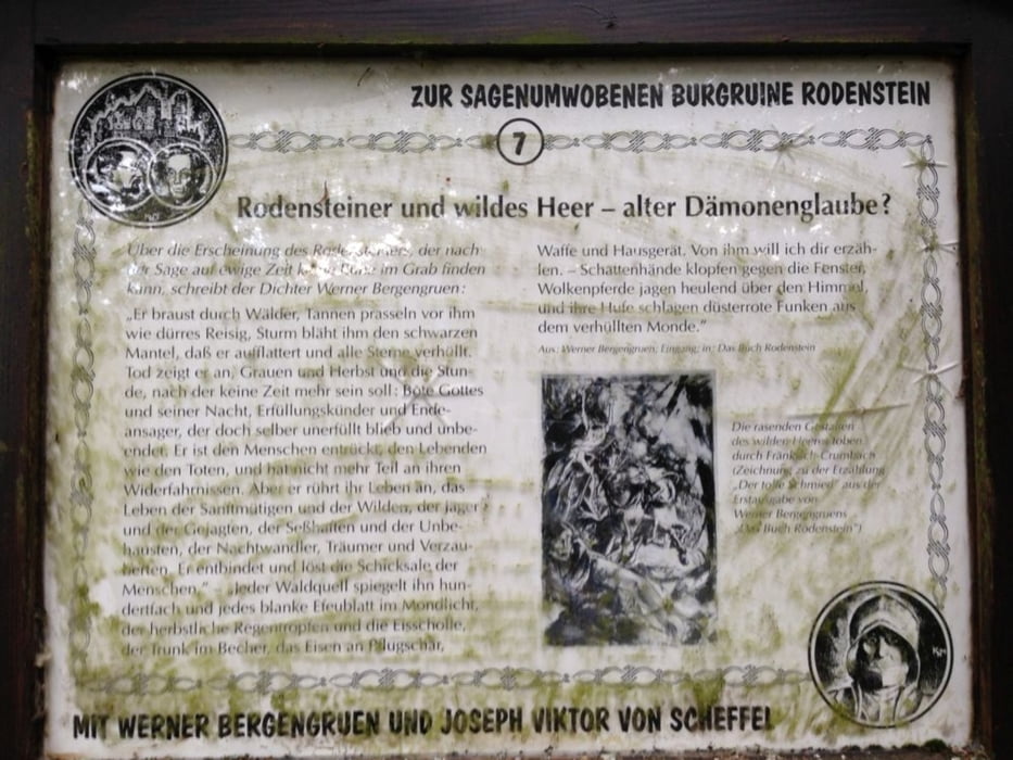
http://de.wikipedia.org/wiki/Burg_RodensteinTour gallery

Tour map and elevation profile
Minimum height 104 m
Maximum height 590 m
More about the tour author
|
|
messer1 |
Comments

Ausgangspunkt ist der rote Turm in Bensheim. Von hier hat man eine super Ausgangssituation um den Odenwald "zu beackern".
Wer will kann auch in Heppenheim starten. Irgendwo zwischen HP und Bensheim gibt es gute Parkmöglichkeiten.
Bei Anreise mit dem Zug ist sicherlich Bensheim die bessere Ausgangsmöglichkeit.
GPS tracks
Trackpoints-
GPX / Garmin Map Source (gpx) download
-
TCX / Garmin Training Center® (tcx) download
-
CRS / Garmin Training Center® (crs) download
-
Google Earth (kml) download
-
G7ToWin (g7t) download
-
TTQV (trk) download
-
Overlay (ovl) download
-
Fugawi (txt) download
-
Kompass (DAV) Track (tk) download
-
Track data sheet (pdf) download
-
Original file of the author (gpx) download
More about the tour author
|
|
messer1 |
Add to my favorites
Remove from my favorites
Edit tags
Open track
My score
Rate