

Wie alle meine Touren, aufwärts Asphaltvermeidung wo geht....
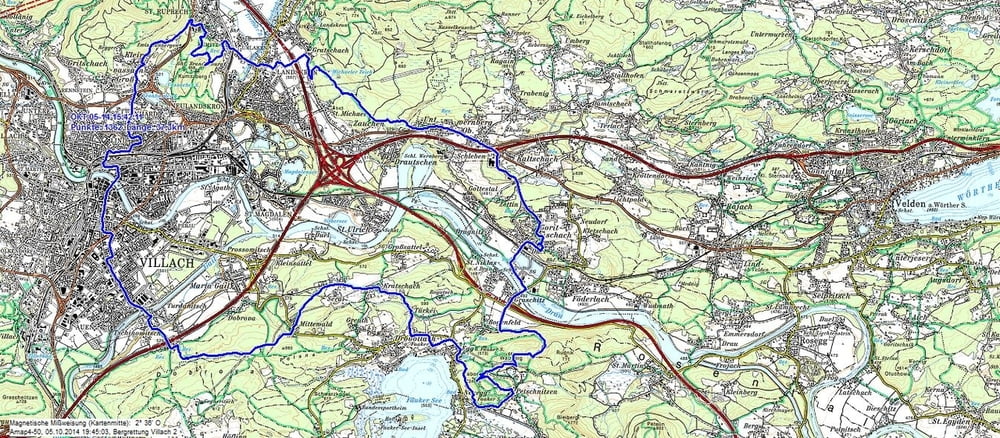
Die Tour führt über Steige auf Teile des Oswaldiberges, dem Kumberg (Brandenburg), Landskron vorbei am Michaeler Teich nach Wernberg. Anschließend wird das Tal nach Bogenfeld überquert, und wiederum geht es über Steige auf den Tabor. Die Abfahrt nach Ledenitzen führt über manch Wurzel und Laubwegen. Vor der Einmündung auf die Faakersee Straße geht es vorbei an einem Hotel über einen neuen Forstweg nach Egg, und nach dem Restaurant Hazienda in die Türkei und hinauf nach Latschach. Der nächste Punkt ist Mittewald, über den es dann auf die Dobrova und nach Tschinowitsch geht.
Alles in allem eine interessante Tour, die manach tricky Wege beinhaltet.
Tour map and elevation profile
Minimum height 488 m
Maximum height 737 m
More about the tour author
|
|
johnatan |
Comments

Villach Lind / Treffner Straße
GPS tracks
Trackpoints-
GPX / Garmin Map Source (gpx) download
-
TCX / Garmin Training Center® (tcx) download
-
CRS / Garmin Training Center® (crs) download
-
Google Earth (kml) download
-
G7ToWin (g7t) download
-
TTQV (trk) download
-
Overlay (ovl) download
-
Fugawi (txt) download
-
Kompass (DAV) Track (tk) download
-
Track data sheet (pdf) download
-
Original file of the author (gpx) download
More about the tour author
|
|
johnatan |
Add to my favorites
Remove from my favorites
Edit tags
Open track
My score
Rate