


Dies ist nur eine von vielen herrlichen Touren die man in Weinstadt abradeln kann.
In Weinstadt gibts keine Alpen. Dafür aber
Weinberge, Dörfer, Wälder, Städte und Kultur.
Damit kann man viele spannende und schöne Radtouren planen.
Leider empfiehlt die örtliche Verantwortlichkeit nur eine schreckliche "Weinstadttour" als Radtip.
Diese Beispielstour hier zeigt die ganze Schönheit der Weinberge die Weinstadt zu bieten hat. Man fährt über die schönsten Höhenwege mit klasse Ausblicke und kreuzt spannende Orte.
Seminarort Landgut Burg mit seinem kleinem Vogelzoo, der Schnaiter Skulpturenpfad mit Motiven des Weinanbaues, das heimliche Wahrzeichen Schönbühl, der Weinlehrpfad Beutelsbach und die Ruine Kappelberg aus dem 11.Jhd.
Further information at
http://danke-sagen.deTour gallery
Tour map and elevation profile
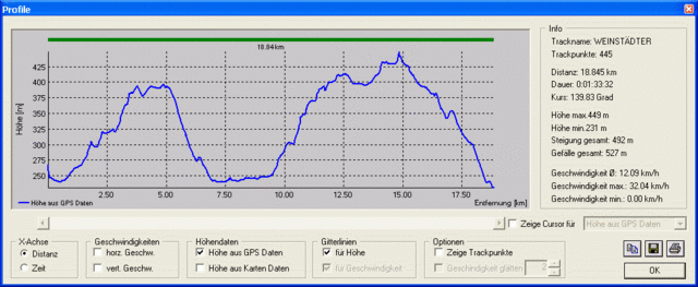
Minimum height 231 m
Maximum height 449 m
More about the tour author
|
|
reviloilover |
Comments

Startpunkt Endpunkt Rathaus Beutelsbach
GPS tracks
Trackpoints-
GPX / Garmin Map Source (gpx) download
-
TCX / Garmin Training Center® (tcx) download
-
CRS / Garmin Training Center® (crs) download
-
Google Earth (kml) download
-
G7ToWin (g7t) download
-
TTQV (trk) download
-
Overlay (ovl) download
-
Fugawi (txt) download
-
Kompass (DAV) Track (tk) download
-
Track data sheet (pdf) download
-
Original file of the author (gpx) download
More about the tour author
|
|
reviloilover |
Add to my favorites
Remove from my favorites
Edit tags
Open track
My score
Rate