Login

Forgotten password?

Cookies have to be accepted!
Your browser's cookie functionality is disabled. Please enable this functionality.

Not a member yet?

Register now
Login

Available for registred users only

Log in to use this feature.

Forgotten password?

Cookies have to be accepted!
Your browser's cookie functionality is disabled. Please enable this functionality.

Not a member yet?

Register now
Filter
Categories
Advanced filters
  • Distance (km)
  • Height
Save filters Reset filter

TrackRank

QRCode

Technical data

Distance21,3 km Height547 m Way down496 m Duration02:00 h:m Date26.03.2008
Scores Author Landscape Fun factor Fitness Technique

Statistics

525 Views Scores 108 Downloads Average
Rate
  • Track data sheet
  • Directions
  • Downloads
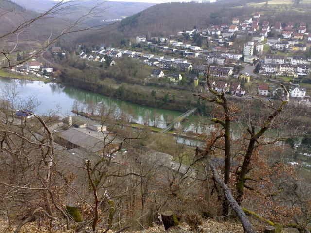
Knapp 2-stündige Tour über Kloster Allerheiligenberg, dann den Lichterkopf (nicht ganz) hoch und weiter nach Koblenz. Von dort zurück nach Lahnstein und Lahnstein auf der Höhe. Technisch wenig knifflig, aber landschaftlich schön. Auch wieder ein Teil des Rheinsteigs.

Tour map and elevation profile

  • Open Street Map
  • Google
Minimum height 61 m Maximum height 310 m Detailed view

More about the tour author

berufsradler
Member since 2007

Send private message

Comments

GPS tracks

Trackpoints
  • GPX / Garmin Map Source (gpx) download
  • TCX / Garmin Training Center® (tcx) download
  • CRS / Garmin Training Center® (crs) download
  • Google Earth (kml) download
  • G7ToWin (g7t) download
  • TTQV (trk) download
  • Overlay (ovl) download
  • Fugawi (txt) download
  • Kompass (DAV) Track (tk) download
  • Track data sheet (pdf) download
  • Original file of the author (gpx) download

More about the tour author

berufsradler
Member since 2007

Send private message
Share track
Add to my favorites
Remove from my favorites
Edit tags
My score
Rate
Track: Lichterkopf
Type: Mountain bike
Distance: 21,3 km
Evaluated on:
Duration:
Day(s)
Hour(s)
Minute(s)
Score: Landscape Fun factor Fitness Technique