Login

Forgot your login?

Cookies have to be accepted!
Your browser's cookie functionality is disabled. Please enable this functionality.

Not a member yet?

Register now
Login

Available for registred users only

Log in to use this feature.

Forgot your login?

Cookies have to be accepted!
Your browser's cookie functionality is disabled. Please enable this functionality.

Not a member yet?

Register now
Filter
Categories
Advanced filters
  • Distance (km)
  • Height
Save filters Reset filter

TrackRank

QRCode

Technical data

Distance38,6 km Height733 m Way down745 m Duration00:00 h:m Date06.04.2008
Scores Author Landscape Fun factor Fitness Technique

Statistics

2134 Views 1 Score 151 Downloads 1.00 Average
Rate
  • Track data sheet
  • Directions
  • Downloads
Für alle die gerne mal das Kyffhüser Mountainbike Rennen nachfahren möchten!

Tour gallery

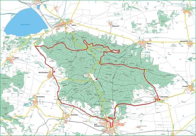
Tour map and elevation profile

  • Open Street Map
  • Google
Minimum height 126 m Maximum height 577 m Detailed view

More about the tour author

Rauscher78
Member since 2007

Send private message

Comments

GPS tracks

Trackpoints
  • GPX / Garmin Map Source (gpx) download
  • TCX / Garmin Training Center® (tcx) download
  • CRS / Garmin Training Center® (crs) download
  • Google Earth (kml) download
  • G7ToWin (g7t) download
  • TTQV (trk) download
  • Overlay (ovl) download
  • Fugawi (txt) download
  • Kompass (DAV) Track (tk) download
  • Track data sheet (pdf) download
  • Original file of the author (gpx) download

More about the tour author

Rauscher78
Member since 2007

Send private message
Share track
Add to my favorites
Remove from my favorites
Edit tags
My score
Rate
Track: Kyffhäuser Berglauf Mountenbike
Type: Mountain bike
Distance: 38,6 km
Evaluated on:
Duration:
Day(s)
Hour(s)
Minute(s)
Score: Landscape Fun factor Fitness Technique