Login

Forgot your login?

Cookies have to be accepted!
Your browser's cookie functionality is disabled. Please enable this functionality.

Not a member yet?

Register now
Login

Available for registred users only

Log in to use this feature.

Forgot your login?

Cookies have to be accepted!
Your browser's cookie functionality is disabled. Please enable this functionality.

Not a member yet?

Register now
Filter
Categories
Advanced filters
  • Distance (km)
  • Height
Save filters Reset filter

TrackRank

QRCode

Technical data

Distance135,5 km Height1885 m Way down1879 m Duration05:15 h:m Date09.11.2015
Scores Author Landscape Fun factor Fitness Technique

Statistics

265 Views Scores 51 Downloads Average
Rate
  • Track data sheet
  • Directions
  • Downloads

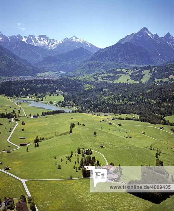
Die Tour von Urfeld am Walchensee in die Leutasch in Tirol ist soweit bekannt, aber wegen des niedrigen Sonnenstandes Anfang November (bis 11:00 schattig in Nordteil der Leutasch!) wurde noch ausgiebig über die Buckelwiesen zwischen Krün und Mittenwald gebügelt, hier durfte das Laktat regieren!!


Tour map and elevation profile

  • Open Street Map
  • Google
Minimum height 767 m Maximum height 1220 m Detailed view

More about the tour author

Mathis_muc
Member since 2008

Send private message

Comments

GPS tracks

Trackpoints
  • GPX / Garmin Map Source (gpx) download
  • TCX / Garmin Training Center® (tcx) download
  • CRS / Garmin Training Center® (crs) download
  • Google Earth (kml) download
  • G7ToWin (g7t) download
  • TTQV (trk) download
  • Overlay (ovl) download
  • Fugawi (txt) download
  • Kompass (DAV) Track (tk) download
  • Track data sheet (pdf) download
  • Original file of the author (gpx) download

More about the tour author

Mathis_muc
Member since 2008

Send private message
Share track
Add to my favorites
Remove from my favorites
Edit tags
My score
Rate
Track: Walchensee-Leutasch-Buckelwiesen
Type: Mountain bike
Distance: 135,5 km
Evaluated on:
Duration:
Day(s)
Hour(s)
Minute(s)
Score: Landscape Fun factor Fitness Technique