


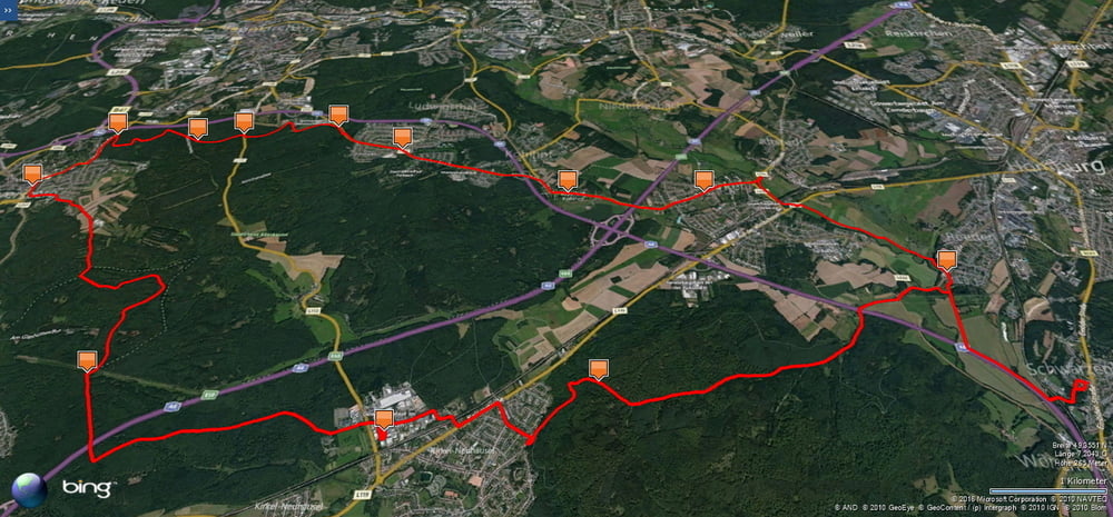
Am Morgen radelte ich auf meiner Lieblingstrecke von Homburg Schwarzenbach nach Kirkel Neuhäusel.
Am Abend fuhr ich dann in den Wald westlich von Neuhäusel um dann die Autobahn zu unterqueren und meinen ersten höheren Punkt zu erreichen. Auf einem schönen Feldweg fuhr ich in das Kleberbachtal ab um dann gleich wieder bergan zu fahren.
Ich erreichte Elversberg Spiesen und fuhr nun in Richtung Neunkirchen. Kurz vor der A8 bog ich in den Wald ab und fuhr auf unterschiedlichen Wegen nach Furpach und weiter durch die Kohlhöfe nach Kirkel Limbach.
Ab hier nahm ich den Radweg im Tal über Beeden zu meinem Ausgangspunkt.
Further information at
https://de.wikipedia.org/wiki/Landkreis_NeunkirchenTour gallery

Tour map and elevation profile
Minimum height 227 m
Maximum height 361 m
More about the tour author
|
|
Pheinz |
Comments

Start und Ziel in Homburg Schwarzenbach
GPS tracks
Trackpoints-
GPX / Garmin Map Source (gpx) download
-
TCX / Garmin Training Center® (tcx) download
-
CRS / Garmin Training Center® (crs) download
-
Google Earth (kml) download
-
G7ToWin (g7t) download
-
TTQV (trk) download
-
Overlay (ovl) download
-
Fugawi (txt) download
-
Kompass (DAV) Track (tk) download
-
Track data sheet (pdf) download
-
Original file of the author (gpx) download
More about the tour author
|
|
Pheinz |
Add to my favorites
Remove from my favorites
Edit tags
Open track
My score
Rate