


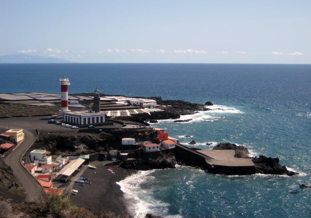
Landschaftlich reizvolle Tour zu zwei Vulkanen im Süden. Start am Kiosk Playa Zamora (Wegpunkt 23 auf der Karte). Entlang der Küste auf Asphalt und Bananenplantagen zum Leuchtturm Faro de Fuencaliente (Wegpunkt 25, Einkehrmöglichkeit) und angrenzenden Salinenfeldern. Dann auf gut befahrbarer Piste durch bizarre Lavafelder hinauf zu den Vulkanen (laut Guide ca. 900 hm am Stück). Wir haben jeweils die Bikes abgestellt und sind zu Fuß zu den Säumen der Vulkankrater gelaufen. Am Teneguia war das noch ein ganzes Stück und es war völlig menschenleer (Wegpunkt 27). Am San Antonio (Wegpunkt 28) befindet sich hingegen ein Besucherzentrum und es war bevölkert. Zurück zum Start ging es über eine Serpentinenabfahrt, hoch über den Bananenplantagen. Zum Schluß dieser herrlichen Tour nette Einkehr im Kiosk mit Blick auf Strand.
2009 von uns gefahren. Ich hatte noch kein Navi und habe das File per Hand erstellt, deswegen kein Höhenprofil.
Wir haben gute Erfahrungen mit dem freundlichen MTB Verleih in Puerto Naos gemacht (siehe Link).
Further information at
http://www.bike-station.de/index.htmTour gallery


Tour map and elevation profile
Minimum height 99999 m
Maximum height -99999 m
More about the tour author
|
|
mackator |
Comments

Kiosk Playa Zamora
GPS tracks
Trackpoints-
GPX / Garmin Map Source (gpx) download
-
TCX / Garmin Training Center® (tcx) download
-
CRS / Garmin Training Center® (crs) download
-
Google Earth (kml) download
-
G7ToWin (g7t) download
-
TTQV (trk) download
-
Overlay (ovl) download
-
Fugawi (txt) download
-
Kompass (DAV) Track (tk) download
-
Track data sheet (pdf) download
-
Original file of the author (gpx) download
More about the tour author
|
|
mackator |
Add to my favorites
Remove from my favorites
Edit tags
Open track
My score
Rate