Login

Forgot your login?

Cookies have to be accepted!
Your browser's cookie functionality is disabled. Please enable this functionality.

Not a member yet?

Register now
Login

Available for registred users only

Log in to use this feature.

Forgot your login?

Cookies have to be accepted!
Your browser's cookie functionality is disabled. Please enable this functionality.

Not a member yet?

Register now
Filter
Categories
Advanced filters
  • Distance (km)
  • Height
Save filters Reset filter

TrackRank

QRCode

Technical data

Distance33,4 km Height760 m Way down762 m Duration02:30 h:m Date07.06.2020
Scores Author Landscape Fun factor Fitness Technique

Statistics

91 Views Scores 20 Downloads Average
Rate
  • Track data sheet
  • Directions
  • Downloads
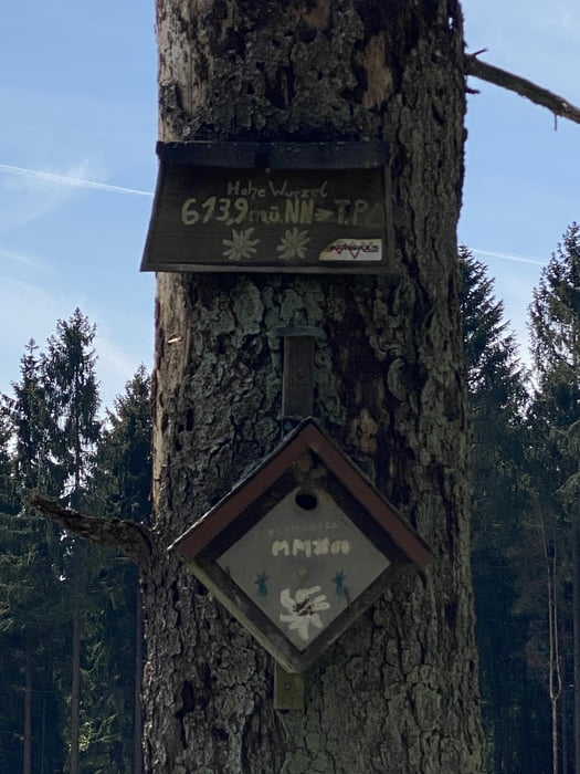
Vom Schiersteiner Hafen zunächst durch Obstgärten, dann Weinberge hinein in die Taunuswälder, Frauenstein, Georgenborn, bis hinauf zum höchsten Punkt, der hohen Wurzel, Abfahrt nach Schlangenbad mit einem kurzen Singletrail, dann hinunter ins Martinstal, zurück über Frauenstein.

Tour map and elevation profile

  • Open Street Map
  • Google
Minimum height 95 m Maximum height 620 m Detailed view

More about the tour author

Telebike
Member since 2008

Send private message

Comments

GPS tracks

Trackpoints
  • GPX / Garmin Map Source (gpx) download
  • TCX / Garmin Training Center® (tcx) download
  • CRS / Garmin Training Center® (crs) download
  • Google Earth (kml) download
  • G7ToWin (g7t) download
  • TTQV (trk) download
  • Overlay (ovl) download
  • Fugawi (txt) download
  • Kompass (DAV) Track (tk) download
  • Track data sheet (pdf) download
  • Original file of the author (gpx) download

More about the tour author

Telebike
Member since 2008

Send private message
Share track
Add to my favorites
Remove from my favorites
Edit tags
My score
Rate
Track: Taunusgewurzel
Type: Mountain bike
Distance: 33,4 km
Evaluated on:
Duration:
Day(s)
Hour(s)
Minute(s)
Score: Landscape Fun factor Fitness Technique