Login

Forgot your login?

Cookies have to be accepted!
Your browser's cookie functionality is disabled. Please enable this functionality.

Not a member yet?

Register now
Login

Available for registred users only

Log in to use this feature.

Forgot your login?

Cookies have to be accepted!
Your browser's cookie functionality is disabled. Please enable this functionality.

Not a member yet?

Register now
Filter
Categories
Advanced filters
  • Distance (km)
  • Height
Save filters Reset filter

TrackRank

QRCode

Technical data

Distance37,2 km Height230 m Way down233 m Duration02:15 h:m Date21.06.2020
Scores Author Landscape Fun factor Fitness Technique

Statistics

289 Views Scores 5 Downloads Average
Rate
  • Track data sheet
  • Directions
  • Downloads

Sonntagstour!

Dies ist eine kleine Radtour mit Querung des TÜPL in Bruckneudorf.

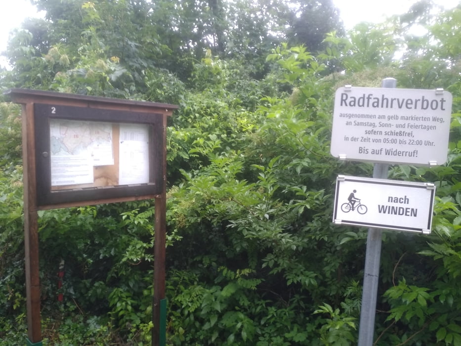
Meist ist dies nur an Sonn-, und Feiertagen erlaubt.

Die Strecke führt vom Gemeindeamt in Weiden am See über Neusiedl am See, dem Outlet Center, Parndorf, Bruckneudorf über den Truppenübungsplatz Richtung Winden nach Jois, Neusiedl am See und zurück nach Weiden.

ES wird auf Radwegen und Güterwegen gefahren. Ca. 6 km Schotterweg sind dabei.


Tour map and elevation profile

  • Open Street Map
  • Google
Minimum height 111 m Maximum height 214 m Detailed view

More about the tour author

Jonas6x62
Member since 2020

Send private message

Comments

GPS tracks

Trackpoints
  • GPX / Garmin Map Source (gpx) download
  • TCX / Garmin Training Center® (tcx) download
  • CRS / Garmin Training Center® (crs) download
  • Google Earth (kml) download
  • G7ToWin (g7t) download
  • TTQV (trk) download
  • Overlay (ovl) download
  • Fugawi (txt) download
  • Kompass (DAV) Track (tk) download
  • Track data sheet (pdf) download
  • Original file of the author (gpx) download

More about the tour author

Jonas6x62
Member since 2020

Send private message
Share track
Add to my favorites
Remove from my favorites
Edit tags
My score
Rate
Track: TÜPL Querung Bruckneudorf - Winden
Type: Trekkingbike
Distance: 37,2 km
Evaluated on:
Duration:
Day(s)
Hour(s)
Minute(s)
Score: Landscape Fun factor Fitness Technique