Login

Forgot your login?

Cookies have to be accepted!
Your browser's cookie functionality is disabled. Please enable this functionality.

Not a member yet?

Register now
Login

Available for registred users only

Log in to use this feature.

Forgot your login?

Cookies have to be accepted!
Your browser's cookie functionality is disabled. Please enable this functionality.

Not a member yet?

Register now
Filter
Categories
Advanced filters
  • Distance (km)
  • Height
Save filters Reset filter

TrackRank

QRCode

Technical data

Distance45,9 km Height1163 m Way down1056 m Duration00:00 h:m Date20.12.2021
Scores Author Landscape Fun factor Fitness Technique

Statistics

150 Views Scores 13 Downloads Average
Rate
  • Track data sheet
  • Directions
  • Downloads

Start der Tour ist Bahnhof Hasslinghausen am Rennebaum.

Parken ist möglich.

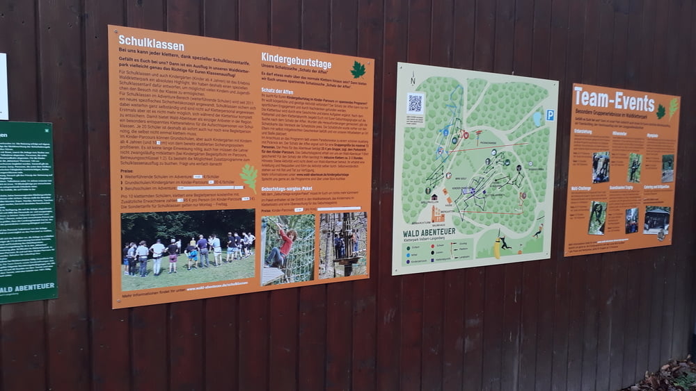
Rast und Essen ist möglich, am Berger Hof, anderer Hof, Bahnhof Schee und irgendein Turm am Kletterwald

Tour gallery

Tour map and elevation profile

  • Open Street Map
  • Google
Minimum height 70 m Maximum height 299 m Detailed view

More about the tour author

rotwilder
Member since 2009

Send private message

Comments

GPS tracks

Trackpoints
  • GPX / Garmin Map Source (gpx) download
  • TCX / Garmin Training Center® (tcx) download
  • CRS / Garmin Training Center® (crs) download
  • Google Earth (kml) download
  • G7ToWin (g7t) download
  • TTQV (trk) download
  • Overlay (ovl) download
  • Fugawi (txt) download
  • Kompass (DAV) Track (tk) download
  • Track data sheet (pdf) download
  • Original file of the author (gpx) download

More about the tour author

rotwilder
Member since 2009

Send private message
Share track
Add to my favorites
Remove from my favorites
Edit tags
My score
Rate
Track: Felderbach
Type: Mountain bike
Distance: 45,9 km
Evaluated on:
Duration:
Day(s)
Hour(s)
Minute(s)
Score: Landscape Fun factor Fitness Technique