
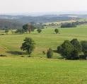

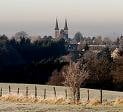
Rennradtour in sehr schöner Landschaft mit herrlichen Ausblicken auf wenig befahrenen Straßen und Wirtschaftswegen. Start in Neunkirchen am Rathaus oder Markt (Parkplätze). Es wird empfohlnen, die Tour im Uhrzeigersinn zu fahren.
Further information at
http://www.neunkirchen-seelscheid.deTour gallery
Tour map and elevation profile
Minimum height 98 m
Maximum height 347 m
More about the tour author

|
jkrieger |
Comments

Von der A3 aus Richtung Frankfurt Abfahrt 30b Lohmar Nord Richtung Neunkirchen (B507). Von der A3 aus Richtung Köln Abfahrt 30a Rösrath, der L288 Richtung Donrath und dann B507 Richtung Neunkirchen
GPS tracks
Trackpoints-
GPX / Garmin Map Source (gpx) download
-
TCX / Garmin Training Center® (tcx) download
-
CRS / Garmin Training Center® (crs) download
-
Google Earth (kml) download
-
G7ToWin (g7t) download
-
TTQV (trk) download
-
Overlay (ovl) download
-
Fugawi (txt) download
-
Kompass (DAV) Track (tk) download
-
Track data sheet (pdf) download
-
Original file of the author (gpx) download
More about the tour author
|
|
jkrieger |
Add to my favorites
Remove from my favorites
Edit tags
Open track
My score
Rate