Login

Forgotten password?

Cookies have to be accepted!
Your browser's cookie functionality is disabled. Please enable this functionality.

Not a member yet?

Register now
Login

Available for registred users only

Log in to use this feature.

Forgotten password?

Cookies have to be accepted!
Your browser's cookie functionality is disabled. Please enable this functionality.

Not a member yet?

Register now
Filter
Categories
Advanced filters
  • Distance (km)
  • Height
Save filters Reset filter

TrackRank

QRCode

Technical data

Distance55,7 km Height1193 m Way down1176 m Duration04:00 h:m Date30.06.2008
Scores Author Landscape Fun factor Fitness Technique

Statistics

1729 Views 1 Score 427 Downloads 4.00 Average
Rate
  • Track data sheet
  • Directions
  • Downloads
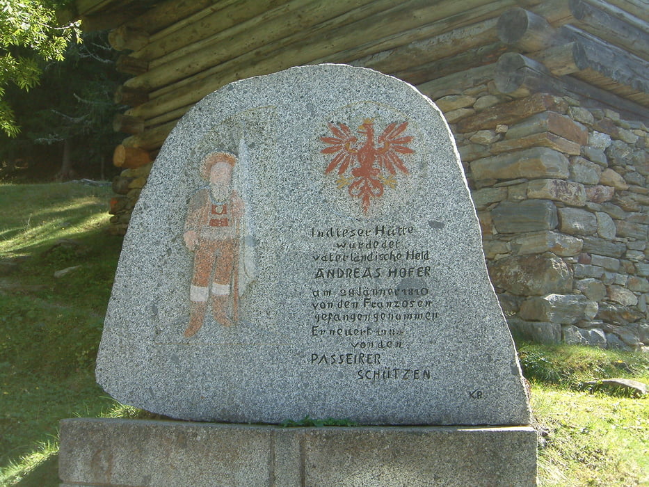
Von Algund durch Meran ins Passeiertal. Dort auf dem Radweg (Schotter) bis St. Martin, weiter auf der asfaltierten Höfezufahrtsstraße bergauf bis zum Pfandlerhof, dann auf einem Forstweg, zuletzt ziemlich steil bis zur Pfandleralm, Zufluchtsort des bekannten tiroler Freiheitskämpfers Andreas Hofer. Auf derselben Route wieder zurück.

Tour gallery

Tour map and elevation profile

  • Open Street Map
  • Google
Minimum height 298 m Maximum height 1355 m Detailed view

More about the tour author

rggps
Member since 2008

Send private message

Comments

Captain on 25.05.2009

Pfandleralm

Technisch einfache aber dennoch sehr schöne Tour zu einem geschichtsträchtigen Ort.
Der Käseteller auf der Alm ist sehr zu empfehlen :o)
Südtirol, Meran, Algung, Parkplatz bei Vellauer Lift.

GPS tracks

Trackpoints
  • GPX / Garmin Map Source (gpx) download
  • TCX / Garmin Training Center® (tcx) download
  • CRS / Garmin Training Center® (crs) download
  • Google Earth (kml) download
  • G7ToWin (g7t) download
  • TTQV (trk) download
  • Overlay (ovl) download
  • Fugawi (txt) download
  • Kompass (DAV) Track (tk) download
  • Track data sheet (pdf) download
  • Original file of the author (gpx) download

More about the tour author

rggps
Member since 2008

Send private message
Share track
Add to my favorites
Remove from my favorites
Edit tags
My score
Rate
Track: Pfandleralm
Type: Mountain bike
Distance: 55,7 km
Evaluated on:
Duration:
Day(s)
Hour(s)
Minute(s)
Score: Landscape Fun factor Fitness Technique