


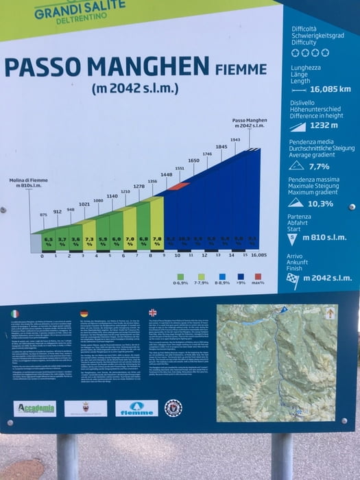
Schwere Tour mit zwei langen Aufstiegen teilweise im zweistelligen Bereich.
Zwei flotte Abfahrten eine mit 15 Km und die zweite mit 20 Km.
Im Valsugana Tal fahren wir über Roncegno und dann auf Brentaradweg bis Caldonazzo. Es folgt eine kurze Auffahrt nach Civezzano, dann hinunter nach Trient und über den Eschtalradweg zurück nach Bozen.
Am Anfang der Tour sind mehrere gut beleuchtete Tunnels zu durchfahren, deshalb Licht nicht vergessen.
Alternativ entweder über Karneid Gummer + 600 Hm, oder mit dem Bus bis Birchabruck -550 Hm.
Wer Strava hat, findet alle meine Touren hier.
Further information at
https://eggental.com/de/SommerTour gallery
Tour map and elevation profile
Minimum height 211 m
Maximum height 1964 m
More about the tour author
|
|
Califan |
Comments

https://www.google.com/maps/place/46%C2%B029'53.7%22N+11%C2%B022'36.4%22E/@46.49824,11.3762288,19z/data=!3m1!4b1!4m14!1m7!3m6!1s0x12cdf5450348b727:0x3c017283ac41265d!2s18038+Sanremo,+Imperia!3b1!8m2!3d43.8159671!4d7.7760567!3m5!1s0x0:0xf9d0730f7d6e2e66!7e2!8m2!3d46.4982404!4d11.3767761
GPS tracks
Trackpoints-
GPX / Garmin Map Source (gpx) download
-
TCX / Garmin Training Center® (tcx) download
-
CRS / Garmin Training Center® (crs) download
-
Google Earth (kml) download
-
G7ToWin (g7t) download
-
TTQV (trk) download
-
Overlay (ovl) download
-
Fugawi (txt) download
-
Kompass (DAV) Track (tk) download
-
Track data sheet (pdf) download
-
Original file of the author (gpx) download
More about the tour author
|
|
Califan |
Add to my favorites
Remove from my favorites
Edit tags
Open track
My score
Rate