


Die Wanderung startet an der Wendeschleife nahe dem Chemnitztalradweg an der Heinersdorfer Straße von Glösa-Draisdorf.
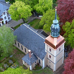
Höhepunkte sind die Gartenbahn, die Pampa jenseits von Wittgensdorf, ein paar Höhenzüge mit "Fernsicht", ein paar FFH`s, die Wittgensdorfer Kirche, der Käse Maik, der Hundesportverein und eben der Weg an sich ... ...
Höhepunkte sind die Gartenbahn, die Pampa jenseits von Wittgensdorf, ein paar Höhenzüge mit "Fernsicht", ein paar FFH`s, die Wittgensdorfer Kirche, der Käse Maik, der Hundesportverein und eben der Weg an sich ... ...
Further information at
https://t.me/FreedomdayteamTour gallery


Tour map and elevation profile
Minimum height 273 m
Maximum height 339 m
More about the tour author
|
|
Saxoniaradler |
Comments

Heinersdorf gehört zu Chemnitz und liegt westlich von Freiberg. Dresden noch liegt viel tiefer im Osten!
Camper sind eh pfiffig und finden den Weg allein.
GPS tracks
Trackpoints-
GPX / Garmin Map Source (gpx) download
-
TCX / Garmin Training Center® (tcx) download
-
CRS / Garmin Training Center® (crs) download
-
Google Earth (kml) download
-
G7ToWin (g7t) download
-
TTQV (trk) download
-
Overlay (ovl) download
-
Fugawi (txt) download
-
Kompass (DAV) Track (tk) download
-
Track data sheet (pdf) download
-
Original file of the author (gpx) download
More about the tour author
|
|
Saxoniaradler |
Add to my favorites
Remove from my favorites
Edit tags
Open track
My score
Rate