


Eine der besten Panorama-MTB Touren die es gibt. Ich bin die Tour in 2 Tagen gefahren, am 1. Tag ca. 14 km / 1100 Hm / 3h, 2. Tag ca. 66 km / 1800 Hm / 8h.
Von St. Christina geht es über die Seiser Alm hinauf zum Friedrich-August Weg (Singletrail mit herrlicher Aussicht), Übernachtung in der Friedrich-August Hütte.
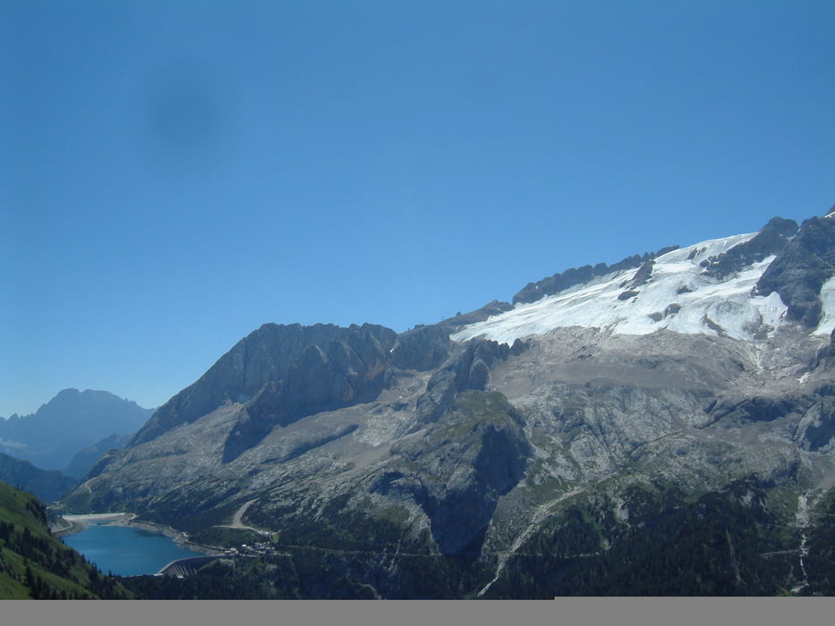
Am 2. Tag gibt es erst einmal eine herrliche Abfahrt, anschließend Aufstieg zum Bindelweg, einer der schönsten Aussichtstrails in den Alpen, aber leider total überlaufen von Touristen. Bei der Abfahrt vom Bindelweg runter zum Fedaia-Stausee habe ich eine äusserst schwierige Variante erwischt (war kaum fahrbar), da gibt es einfachere Varianten. Vom See geht es durch das Val di Fassa bis nach Campitello. Von dort fordert das Duron Tal noch die letzten Reserven - vorsicht steil. Es geht ein letztes Mal rauf auf fast 2200 Hm und von dort gemütlich zurück nach St. Christina.
Von St. Christina geht es über die Seiser Alm hinauf zum Friedrich-August Weg (Singletrail mit herrlicher Aussicht), Übernachtung in der Friedrich-August Hütte.
Am 2. Tag gibt es erst einmal eine herrliche Abfahrt, anschließend Aufstieg zum Bindelweg, einer der schönsten Aussichtstrails in den Alpen, aber leider total überlaufen von Touristen. Bei der Abfahrt vom Bindelweg runter zum Fedaia-Stausee habe ich eine äusserst schwierige Variante erwischt (war kaum fahrbar), da gibt es einfachere Varianten. Vom See geht es durch das Val di Fassa bis nach Campitello. Von dort fordert das Duron Tal noch die letzten Reserven - vorsicht steil. Es geht ein letztes Mal rauf auf fast 2200 Hm und von dort gemütlich zurück nach St. Christina.
Further information at
http://www.mountainbike-magazin.de/sixcms/detail.php?id=89417Tour gallery
Tour map and elevation profile
Minimum height 1326 m
Maximum height 2445 m
More about the tour author

|
77maeuse |
Comments

Frank
on 25.09.2006
Ich bin am WE die Tour gefahren. Vielleicht war meine Erwartung zu groß aber ich bin sehr enttäuscht. OK, die Landschaft ist genial aber die Tour an sich lohnt nicht. Viel zu viel Asphalt. Ich bin die Tour auch in 2 Tagen gefahren allerdings am 1. Tag von St. Christina bis Campitello. Der 2. Tag war ,fahrerisch gesehen, langweilig. Die Tour würde ich auf gar keinen Fall nochmal fahren.
Startpunkt ist im Grödnertal im Ort St. Christina. Parkmöglichkeit beim Sportplatz.
GPS tracks
Trackpoints-
GPX / Garmin Map Source (gpx) download
-
TCX / Garmin Training Center® (tcx) download
-
CRS / Garmin Training Center® (crs) download
-
Google Earth (kml) download
-
G7ToWin (g7t) download
-
TTQV (trk) download
-
Overlay (ovl) download
-
Fugawi (txt) download
-
Kompass (DAV) Track (tk) download
-
Track data sheet (pdf) download
More about the tour author
|
|
77maeuse |
Add to my favorites
Remove from my favorites
Edit tags
Open track
My score
Rate