Login

Forgot your login?

Cookies have to be accepted!
Your browser's cookie functionality is disabled. Please enable this functionality.

Not a member yet?

Register now
Login

Available for registred users only

Log in to use this feature.

Forgot your login?

Cookies have to be accepted!
Your browser's cookie functionality is disabled. Please enable this functionality.

Not a member yet?

Register now
Filter
Categories
Advanced filters
  • Distance (km)
  • Height
Save filters Reset filter

TrackRank

QRCode

Technical data

Distance76,7 km Height4017 m Way down4024 m Duration12:00 h:m Date15.08.2008
Scores Author User Landscape Fun factor Fitness Technique

Statistics

2732 Views 2 Scores 311 Downloads 4.50 Average
Rate
  • Track data sheet
  • Directions
  • Downloads

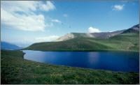
Traumhafte 1 ½ - Tagestour mit Start und Ziel in Jochberg. Bergauf geht’s fast ausschließlich auf gut fahrbaren Forstwegen. Ein kurzes Schiebe- bzw. Tragestück wartet kurz unterhalb des Torsees. (ca. 15min) Bergab warten geniale Singletrails – die teilweise eine sehr gute Fahrtechnik erfordern.

Viel Spaß beim Nachfahren.

Further information at

http://www.kitzalps.com/

Tour map and elevation profile

  • Open Street Map
  • Google
Minimum height 759 m Maximum height 2002 m Detailed view

More about the tour author

Bergdohle
Member since 2008

Send private message

Comments

Wirt on 29.06.2009

Fahrvergnügen

Die Abfahrt vom Pengelstein nach Aschau ist nicht gerade der Hit. Bei schlechtem Wetter kann man das Bike fast komplett runter schieben.

Kostenloser Parkplatz an Seilbahnstation in Jochberg.

GPS tracks

Trackpoints
  • GPX / Garmin Map Source (gpx) download
  • TCX / Garmin Training Center® (tcx) download
  • CRS / Garmin Training Center® (crs) download
  • Google Earth (kml) download
  • G7ToWin (g7t) download
  • TTQV (trk) download
  • Overlay (ovl) download
  • Fugawi (txt) download
  • Kompass (DAV) Track (tk) download
  • Track data sheet (pdf) download
  • Original file of the author (gpx) download

More about the tour author

Bergdohle
Member since 2008

Send private message
Share track
Add to my favorites
Remove from my favorites
Edit tags
My score
Rate
Track: 2 Tages MTB-Tour in den Kitzbühler Bergen
Type: Mountain bike
Distance: 76,7 km
Evaluated on:
Duration:
Day(s)
Hour(s)
Minute(s)
Score: Landscape Fun factor Fitness Technique