Login

Forgot your login?

Cookies have to be accepted!
Your browser's cookie functionality is disabled. Please enable this functionality.

Not a member yet?

Register now
Login

Available for registred users only

Log in to use this feature.

Forgot your login?

Cookies have to be accepted!
Your browser's cookie functionality is disabled. Please enable this functionality.

Not a member yet?

Register now
Filter
Categories
Advanced filters
  • Distance (km)
  • Height
Save filters Reset filter

TrackRank

QRCode

Technical data

Distance97,0 km Height833 m Way down900 m Duration03:24 h:m Date29.08.2008
Scores Author Landscape Fun factor Fitness Technique

Statistics

280 Views Scores 33 Downloads Average
Rate
  • Track data sheet
  • Directions
  • Downloads

Genial ist die neu asphaltierte Strecke von Göbrichen nach Königsbach-Stein (ein Traum).

Das Ziel der Tour ist in diesem Fall der Stau- und Badesee "Emetskinge" in Zaberfeld.

Selbiger sorgt dann für die nötige Abkühlung.

Tour gallery

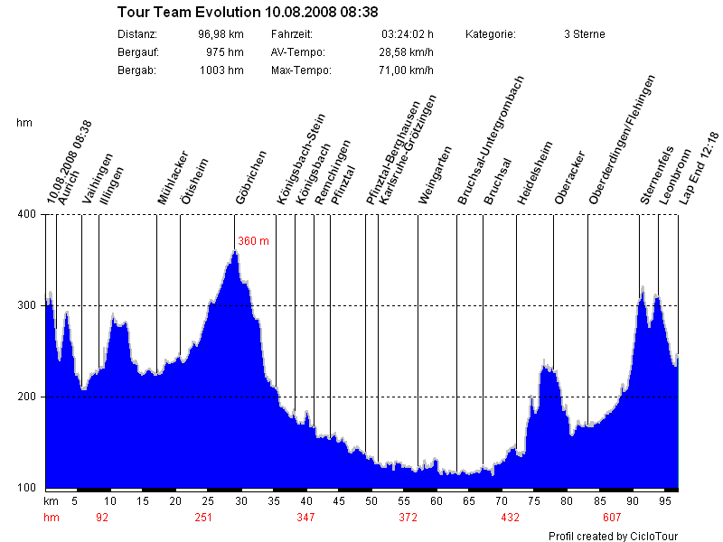
Tour map and elevation profile

  • Open Street Map
  • Google
Minimum height 114 m Maximum height 360 m Detailed view

More about the tour author

gemsweb
Member since 2006

Send private message

Comments

GPS tracks

Trackpoints
  • GPX / Garmin Map Source (gpx) download
  • TCX / Garmin Training Center® (tcx) download
  • CRS / Garmin Training Center® (crs) download
  • Google Earth (kml) download
  • G7ToWin (g7t) download
  • TTQV (trk) download
  • Overlay (ovl) download
  • Fugawi (txt) download
  • Kompass (DAV) Track (tk) download
  • Track data sheet (pdf) download
  • Original file of the author (gpx) download

More about the tour author

gemsweb
Member since 2006

Send private message
Share track
Add to my favorites
Remove from my favorites
Edit tags
My score
Rate
Track: Tour mit Team Sport Evolution am So 10.08.2008
Type: Road biking
Distance: 97,0 km
Evaluated on:
Duration:
Day(s)
Hour(s)
Minute(s)
Score: Landscape Fun factor Fitness Technique