


Wir fahren retour bis zur Strasse wo es links hinauf zur Peeralm geht. Am 2. Parkplatz vorbei und immer der Beschilderung "Seapnalm"weiterfahren.
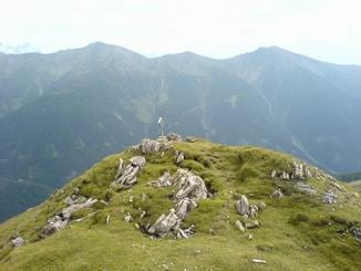
Nach der Seapn Alm führt ein Weg links zum Hirschstein der gut fahrbar ist aber mit etwas mehr Steilheit. Die letzten paar Meter geht man Zufuß hinauf auf den Gipfel. Wenn man über der Waldgrenze ist hat man ein schönes Panorama. Man sieht auch den Übergang ins Voldertal (Naviser Jöchl)
Nach der Seapn Alm führt ein Weg links zum Hirschstein der gut fahrbar ist aber mit etwas mehr Steilheit. Die letzten paar Meter geht man Zufuß hinauf auf den Gipfel. Wenn man über der Waldgrenze ist hat man ein schönes Panorama. Man sieht auch den Übergang ins Voldertal (Naviser Jöchl)
Tour gallery
Tour map and elevation profile
Minimum height 1368 m
Maximum height 2293 m
More about the tour author
|
|
tomi |
Comments

Von Innsbruck nach Matrei weiter ins Navistal bis nach Häusern geradeaus weiter neben dem Bach bis zu einem gebührenpflichtigen Parkplatz. Eine weitere Parkmöglichkeit gibt es wenn mann anstatt geradeaus links hinauf Richtung Peer Alm fährt.
GPS tracks
Trackpoints-
GPX / Garmin Map Source (gpx) download
-
TCX / Garmin Training Center® (tcx) download
-
CRS / Garmin Training Center® (crs) download
-
Google Earth (kml) download
-
G7ToWin (g7t) download
-
TTQV (trk) download
-
Overlay (ovl) download
-
Fugawi (txt) download
-
Kompass (DAV) Track (tk) download
-
Track data sheet (pdf) download
-
Original file of the author (gpx) download
More about the tour author
|
|
tomi |
Add to my favorites
Remove from my favorites
Edit tags
Open track
My score
Rate