


Praktisch immer den weg Entlang der später bei einem Bauernhof zu einem Forstweg wird.
Bei den Wegkreuzungen immer den rechten Weg nehmen. Der Weg hört dann einfach auf und es führt ein schmaler Steig weiter, der mit einem Schild versehen ist"kein Abstieg Absturzgefahr". Der Weg wurde für den Bau der Lawinenschutzeinrichtungen gebaut, und ist nicht sehr steil.
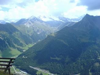
Tolle Aussicht auf die Hintertuxer Gletscher, Olperer...
Bei den Wegkreuzungen immer den rechten Weg nehmen. Der Weg hört dann einfach auf und es führt ein schmaler Steig weiter, der mit einem Schild versehen ist"kein Abstieg Absturzgefahr". Der Weg wurde für den Bau der Lawinenschutzeinrichtungen gebaut, und ist nicht sehr steil.
Tolle Aussicht auf die Hintertuxer Gletscher, Olperer...
Tour gallery
Tour map and elevation profile
Minimum height 1373 m
Maximum height 2147 m
More about the tour author
|
|
tomi |
Comments

von Innsbruck kommend zwischen Steinach und Gries am Brenner nach ST. Jodok Richtung Schmirn. Bei der Siedlung Rohrach bei einer leichten Rechtskurve, vor einem Bauernhof von der Haupstrasse scharf links in eine schmale Strasse einbiegen. Nach ein paar Metern kommt ein kleiner Parkplatz mit einem Marterl dort parken und man startet rechts den Asphaltweg hinauf.
GPS tracks
Trackpoints-
GPX / Garmin Map Source (gpx) download
-
TCX / Garmin Training Center® (tcx) download
-
CRS / Garmin Training Center® (crs) download
-
Google Earth (kml) download
-
G7ToWin (g7t) download
-
TTQV (trk) download
-
Overlay (ovl) download
-
Fugawi (txt) download
-
Kompass (DAV) Track (tk) download
-
Track data sheet (pdf) download
-
Original file of the author (gpx) download
More about the tour author
|
|
tomi |
Add to my favorites
Remove from my favorites
Edit tags
Open track
My score
Rate