


N° 2 Valtenesi.
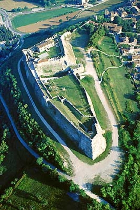
Questo itinerario si sviluppa attraverso le colline della Valtenesi tra Manerba del Garda, Padenghe, Desenzano del Garda, Lonato. E’ il percorso ideale per chi vuole amalgamare la gita in mtb con la cultura i profumi ed i sapori della zona. L’intero percorso non presenta difficoltà tecniche e le salite sono brevi ed accessibili a tutti i tipi di bikers. Esso è ricco di cultura e storia a partire dalla Rocca di Manerba per passare poi vicino ai vari castelli della Valtenesi ( tanto per citarne qualcuno: castello di Padenghe, rocca di Lonato, castello di Drugolo). L’altimetria dell’intero percorso varia dai 90 ai 310 metri sul livello del mare con un dislivello in salita di 436m. Uno degli aspetti che caratterizzano questo itinerario è sicuramente la natura che lo avvolge ed i vari paesini con il loro passato. Durante il percorso non si può fare a meno anche di una sosta nelle varie cantine della zona per una degustazione dei prodotti locali come il famoso vino e l’olio del Garda Bresciano. E perché no uno spunto in più per ritornarci con tutta la famiglia. Proseguendo il giro non manca la voglia di fermarsi in qualche agriturismo per riposarsi ed assaggiare i prodotti locali pranzando. Non poteva di certo mancare la fantastica vista lago quasi sempre presente. Il percorso può diventare una base di partenza per innumerevoli deviazioni per visitare le bellezze della zona. Sconsigliato per famiglie con bimbi piccoli solo per la lunghezza di esso (ciò non toglie la fattibilità di frammentare l’intero percorso in piccole parti per più escursioni anche con bambini). Esso è comunque fattibile con biciclette del tipo mtb per la costante presenza di strade sterrate.
N° 2 Valtenesi. English
This route is spread through the hills of the Valtenesi between Manerba del Garda, Padenghe, Desenzano del Garda, Lonato. And 'the ideal path for those who want to amalgamate the trip mtb with the culture perfumes and flavors of the area. The entire route presents no technical difficulties and the climbs are short and accessible to all types of bikers. It is rich in culture and history from the Fortress of Manerba (Rocca di Manerba), then move close to several castles in the Valtenesi (to name a few: Castle Padenghe, fortress of Lonato, Castle Drugolo). The altimetria their path varies from 90 to 310 metres above sea level with an uphill climb of 436m. One of the features of this journey is surely the nature that surrounds him and the various villages with their past. During the path we can not do without even a pause in the various wineries in the area for a tasting of local products like the famous wine el'olio del Garda Bresciano. And why not one more opportunity to come back for the entire family. Continuing the tour does not lack the will to stop somewhere farmhouse to relax and taste local products lunch. It could not certainly miss the fantastic view of the lake almost always present. The path may become a base for countless detours to visit the beauty of the area. Not recommended for families with small children only for the length of it (the fact remains the feasibility of fragmenting the entire route in small parts for multiple trips with children). It is feasible with bicycle-type mtb for the continued presence of dirt roads.
Ps. Sorry for my english
Tour gallery


Tour map and elevation profile
Minimum height 91 m
Maximum height 310 m
More about the tour author
|
|
ugo-mtb |
Comments

zargoz
on 17.04.2009
Hilfreiche Tour um sich in der gegend etwas umzuschauen und nicht nur die Hauptstasse zu benutzen. Tolle Landschaft.
GPS tracks
Trackpoints-
GPX / Garmin Map Source (gpx) download
-
TCX / Garmin Training Center® (tcx) download
-
CRS / Garmin Training Center® (crs) download
-
Google Earth (kml) download
-
G7ToWin (g7t) download
-
TTQV (trk) download
-
Overlay (ovl) download
-
Fugawi (txt) download
-
Kompass (DAV) Track (tk) download
-
Track data sheet (pdf) download
-
Original file of the author (gpx) download
More about the tour author
|
|
ugo-mtb |
Add to my favorites
Remove from my favorites
Edit tags
Open track
My score
Rate