Login

Forgot your login?

Cookies have to be accepted!
Your browser's cookie functionality is disabled. Please enable this functionality.

Not a member yet?

Register now
Login

Available for registred users only

Log in to use this feature.

Forgot your login?

Cookies have to be accepted!
Your browser's cookie functionality is disabled. Please enable this functionality.

Not a member yet?

Register now
Filter
Categories
Advanced filters
  • Distance (km)
  • Height
Save filters Reset filter

TrackRank

QRCode

Technical data

Distance62,6 km Height1364 m Way down1348 m Duration04:00 h:m Date21.09.2008
Scores Author Landscape Fun factor Fitness Technique

Statistics

1132 Views 1 Score 200 Downloads 4.00 Average
Rate
  • Track data sheet
  • Directions
  • Downloads

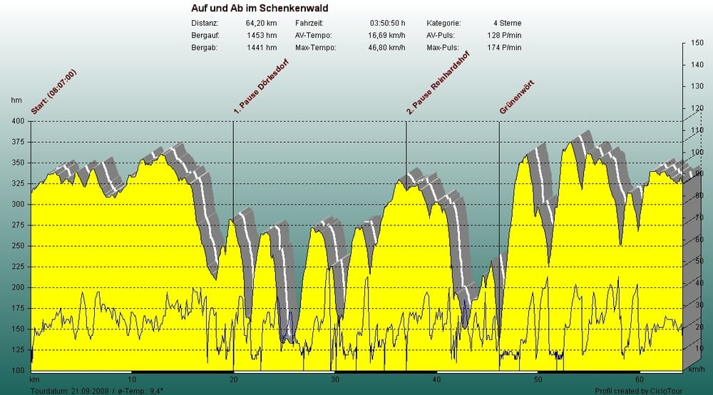
Aufzeichnung der 8. Mountain-Bike-Tour vom 21.09.08 in Wertheim

"Auf und Ab im Schenkenwald"

Veranstalter die Velo Feunde 90 Wertheim e.V

weitere Info über www.velofreunde.de

Super Veranstaltung.

Schöne Landschaft.

Die Strecke biete alles, 

Forstwege, super Trails, schwierige Passagen,


Tour map and elevation profile

  • Open Street Map
  • Google
Minimum height 149 m Maximum height 379 m Detailed view

More about the tour author

ramtmann
Member since 2008

Send private message

Comments

GPS tracks

Trackpoints
  • GPX / Garmin Map Source (gpx) download
  • TCX / Garmin Training Center® (tcx) download
  • CRS / Garmin Training Center® (crs) download
  • Google Earth (kml) download
  • G7ToWin (g7t) download
  • TTQV (trk) download
  • Overlay (ovl) download
  • Fugawi (txt) download
  • Kompass (DAV) Track (tk) download
  • Track data sheet (pdf) download
  • Original file of the author (gpx) download

More about the tour author

ramtmann
Member since 2008

Send private message
Share track
Add to my favorites
Remove from my favorites
Edit tags
My score
Rate
Track: Auf und Ab im Schenkenwald
Type: Mountain bike
Distance: 62,6 km
Evaluated on:
Duration:
Day(s)
Hour(s)
Minute(s)
Score: Landscape Fun factor Fitness Technique