


eine der vielen schlaufen des altmühltalpanoramaweges.
starten sollte man auf jeden fall in altdorf,am besten gegen den uhrzeigersinn,
ich selbst war zunächst leider anders herum unterwegs.
wenn man wieder in altdorf ankommt gibts noch einen verbindungsweg nach erlingshofen,um anschluß zur schlaufe 18 zu haben.(nur sinnvoll wenn man am gleichen tag auch die schlaufe 18 noch fahren möchte.)
dies ist eine sehr schöne schlaufe ,auch weil sie zeitweise durch das anlautertal zieht.
ein höhenprofil ist unter den fotos.
Further information at
http://www.titting.de/Tour gallery


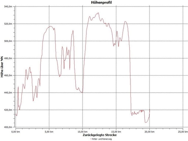
Tour map and elevation profile
Minimum height 99999 m
Maximum height -99999 m
More about the tour author
|
|
tomasi |
Comments

bab münchen - nürnberg, ausfahrt altmühltal,
enkering ,schaffhausen, erlingshofen ,altdorf
GPS tracks
Trackpoints-
GPX / Garmin Map Source (gpx) download
-
TCX / Garmin Training Center® (tcx) download
-
CRS / Garmin Training Center® (crs) download
-
Google Earth (kml) download
-
G7ToWin (g7t) download
-
TTQV (trk) download
-
Overlay (ovl) download
-
Fugawi (txt) download
-
Kompass (DAV) Track (tk) download
-
Track data sheet (pdf) download
-
Original file of the author (gpx) download
More about the tour author
|
|
tomasi |
Add to my favorites
Remove from my favorites
Edit tags
Open track
My score
Rate