Login

Forgot your login?

Cookies have to be accepted!
Your browser's cookie functionality is disabled. Please enable this functionality.

Not a member yet?

Register now
Login

Available for registred users only

Log in to use this feature.

Forgot your login?

Cookies have to be accepted!
Your browser's cookie functionality is disabled. Please enable this functionality.

Not a member yet?

Register now
Filter
Categories
Advanced filters
  • Distance (km)
  • Height
Save filters Reset filter

TrackRank

QRCode

Technical data

Distance24,1 km Height82 m Way down71 m Duration01:00 h:m Date08.02.2009
Scores Author Landscape Fun factor Fitness Technique

Statistics

209 Views Scores 17 Downloads Average
Rate
  • Track data sheet
  • Directions
  • Downloads

Ein ruhiges dahin Radeln.

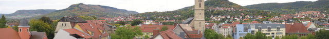
Wenn es mal wieder Aspahlt sein soll und man trotzdem nicht auf der Straße fahren will, dann bietet sich dieser Tourenvorschlag an. Entlang der Saale führen einige geteerte Radwege welche einen schönen Ausblick auf die Kernberge erlauben. Auch für Familien mit Kindern geeignet.

Sehr einfache Tour.

Tour gallery

Tour map and elevation profile

  • Open Street Map
  • Google
Minimum height 132 m Maximum height 160 m Detailed view

More about the tour author

Kempi
Member since 2008

Send private message

Comments

GPS tracks

Trackpoints
  • GPX / Garmin Map Source (gpx) download
  • TCX / Garmin Training Center® (tcx) download
  • CRS / Garmin Training Center® (crs) download
  • Google Earth (kml) download
  • G7ToWin (g7t) download
  • TTQV (trk) download
  • Overlay (ovl) download
  • Fugawi (txt) download
  • Kompass (DAV) Track (tk) download
  • Track data sheet (pdf) download
  • Original file of the author (gpx) download

More about the tour author

Kempi
Member since 2008

Send private message
Share track
Add to my favorites
Remove from my favorites
Edit tags
My score
Rate
Track: Jena Saalerunde
Type: Trekkingbike
Distance: 24,1 km
Evaluated on:
Duration:
Day(s)
Hour(s)
Minute(s)
Score: Landscape Fun factor Fitness Technique