Login

Forgot your login?

Cookies have to be accepted!
Your browser's cookie functionality is disabled. Please enable this functionality.

Not a member yet?

Register now
Login

Available for registred users only

Log in to use this feature.

Forgot your login?

Cookies have to be accepted!
Your browser's cookie functionality is disabled. Please enable this functionality.

Not a member yet?

Register now
Filter
Categories
Advanced filters
  • Distance (km)
  • Height
Save filters Reset filter

TrackRank

QRCode

Technical data

Distance38,5 km Height712 m Way down705 m Duration02:45 h:m Date22.03.2009
Scores Author Landscape Fun factor Fitness Technique

Statistics

846 Views 1 Score 191 Downloads 4.00 Average
Rate
  • Track data sheet
  • Directions
  • Downloads

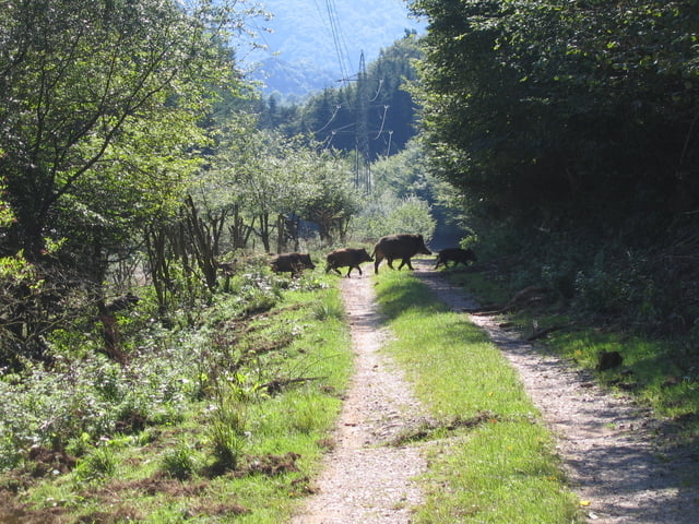
Die Tour geht durch den Vicheler Wald. Wildschweine und evtl. Rehe garantiert.

Tolle Aussicht in das Ahrtal.

Tour map and elevation profile

  • Open Street Map
  • Google
Minimum height 122 m Maximum height 381 m Detailed view

More about the tour author

rororo
Member since 2008

Send private message

Comments

mareu75 on 10.10.2010

Schöne Landschaft, mit leichter Tour

Tour gefällt mir. Bin sie schon 2 x gefahren. Sehr schöne Landschaft. Technik und Kondition werden nicht wirklich sehr gefordert, aber dass macht die Tour nicht unintressanter. Eine schwierige Stelle ist der Weinberg den man hochfahren muss. Deshalb werde ich die Strecke beim nächsten Mal andersherum fahren. Mal schauen wie's wird.
A 61 bis Abfahrt Rheinbach dann in Richtung Wormersdorf. Dort kann man gut den Wagen parken.

GPS tracks

Trackpoints
  • GPX / Garmin Map Source (gpx) download
  • TCX / Garmin Training Center® (tcx) download
  • CRS / Garmin Training Center® (crs) download
  • Google Earth (kml) download
  • G7ToWin (g7t) download
  • TTQV (trk) download
  • Overlay (ovl) download
  • Fugawi (txt) download
  • Kompass (DAV) Track (tk) download
  • Track data sheet (pdf) download
  • Original file of the author (gpx) download

More about the tour author

rororo
Member since 2008

Send private message
Share track
Add to my favorites
Remove from my favorites
Edit tags
My score
Rate
Track: Wildschweinahrtour
Type: Mountain bike
Distance: 38,5 km
Evaluated on:
Duration:
Day(s)
Hour(s)
Minute(s)
Score: Landscape Fun factor Fitness Technique