Login

Forgot your login?

Cookies have to be accepted!
Your browser's cookie functionality is disabled. Please enable this functionality.

Not a member yet?

Register now
Login

Available for registred users only

Log in to use this feature.

Forgot your login?

Cookies have to be accepted!
Your browser's cookie functionality is disabled. Please enable this functionality.

Not a member yet?

Register now
Filter
Categories
Advanced filters
  • Distance (km)
  • Height
Save filters Reset filter

TrackRank

QRCode

Technical data

Distance29,1 km Height1099 m Way down1173 m Duration02:40 h:m Date14.04.2009
Scores Author Landscape Fun factor Fitness Technique

Statistics

782 Views Scores 250 Downloads Average
Rate
  • Track data sheet
  • Directions
  • Downloads

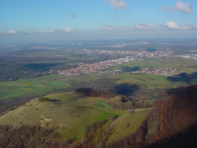
Wunderschöne Tour auf die Burg Teck (2 mal) mit tollem Ausblick und spaßigen SingleTrails (vor allem bergab).  Die Richtung der Tour sollte auf jeden Fall gegen den Uhrzeigersinn gefahren werden (siehe auch Wegepunkte).

Tour map and elevation profile

  • Open Street Map
  • Google
Minimum height 360 m Maximum height 775 m Detailed view

More about the tour author

java1007
Member since 2008

Send private message

Comments

SRiedlinger on 27.12.2009

nur mal so...

jetzt kann ich deine Daten auf mein Mini-Garmin laden...
=> schade, dass wir am Gardasee nicht eine Route nachfahren!

Stefan
Autobahnabfahrt A8 Kirchheim-Ost dann Richtung Owen. Links Abfahren Richtung Nabern, wo die Tour startet.

GPS tracks

Trackpoints
  • GPX / Garmin Map Source (gpx) download
  • TCX / Garmin Training Center® (tcx) download
  • CRS / Garmin Training Center® (crs) download
  • Google Earth (kml) download
  • G7ToWin (g7t) download
  • TTQV (trk) download
  • Overlay (ovl) download
  • Fugawi (txt) download
  • Kompass (DAV) Track (tk) download
  • Track data sheet (pdf) download
  • Original file of the author (gpx) download

More about the tour author

java1007
Member since 2008

Send private message
Share track
Add to my favorites
Remove from my favorites
Edit tags
My score
Rate
Track: Burg Teck_und_Umgebung_1
Type: Mountain bike
Distance: 29,1 km
Evaluated on:
Duration:
Day(s)
Hour(s)
Minute(s)
Score: Landscape Fun factor Fitness Technique