


Der Heslacher Blaustrümplerweg ist ein Höhenwanderweg rund um Heslach und der Karlshöhe von dem man aus sehr schöne Ausblicke auf die Landeshauptstadt hat. Auf dem Blaustrümplerweg zu biken, bedeutet für den Teilnehmer, Abfahrten auf Schotterpisten, Knackige Aufstiege im Heslacher Wald und auf der Weinsteige ( wer möchte kann auch die Zacke benützen ).
Meine Route beginnt im Gegensatz zur Wanderkarte, die per Download auf der VVS.de Seite erhältlich ist, an der Zahnradbahnhaltestelle "Haigst" und geht im Uhrzeigersinn. Natürlich lässt sich diese Tour auch von jedem beliebigen anderen Punkt der Gesamtstrecke oder in der Gegenrichtung unternehmen.
Viel Spass beim Biken
Further information at
http://www.vvs.de/download/freizeitportal/flyer/blaustr_faltblatt.pdfTour gallery
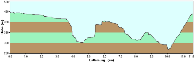
Tour map and elevation profile
Minimum height 268 m
Maximum height 446 m
More about the tour author
|
|
RJP |
Comments

Von der Innenstadt:
Am besten mit der U-Bahn ( Mitnahme vom Rad kostenlos möglich ) zur Weinsteige und dann per Rad (ca. 150m ) bis zur Haltestelle Haigst( Zahnradbahn ).
Von ausserhalb Stuttgarts und mit dem Auto empfiehlt es sich die Parkplätze am Waldfriedhof zu benützen und die Tour dort zu beginnen.
Am besten mit der U-Bahn ( Mitnahme vom Rad kostenlos möglich ) zur Weinsteige und dann per Rad (ca. 150m ) bis zur Haltestelle Haigst( Zahnradbahn ).
Von ausserhalb Stuttgarts und mit dem Auto empfiehlt es sich die Parkplätze am Waldfriedhof zu benützen und die Tour dort zu beginnen.
GPS tracks
Trackpoints-
GPX / Garmin Map Source (gpx) download
-
TCX / Garmin Training Center® (tcx) download
-
CRS / Garmin Training Center® (crs) download
-
Google Earth (kml) download
-
G7ToWin (g7t) download
-
TTQV (trk) download
-
Overlay (ovl) download
-
Fugawi (txt) download
-
Kompass (DAV) Track (tk) download
-
Track data sheet (pdf) download
-
Original file of the author (gpx) download
More about the tour author
|
|
RJP |
Add to my favorites
Remove from my favorites
Edit tags
Open track
My score
Rate