Login

Forgot your login?

Cookies have to be accepted!
Your browser's cookie functionality is disabled. Please enable this functionality.

Not a member yet?

Register now
Login

Available for registred users only

Log in to use this feature.

Forgot your login?

Cookies have to be accepted!
Your browser's cookie functionality is disabled. Please enable this functionality.

Not a member yet?

Register now
Filter
Categories
Advanced filters
  • Distance (km)
  • Height
Save filters Reset filter

TrackRank

QRCode

Technical data

Distance75,3 km Height0 m Way down0 m Duration04:07 h:m Date22.06.2009
Scores Author Landscape Fun factor Fitness Technique

Statistics

844 Views 1 Score 141 Downloads 4.00 Average
Rate
  • Track data sheet
  • Directions
  • Downloads
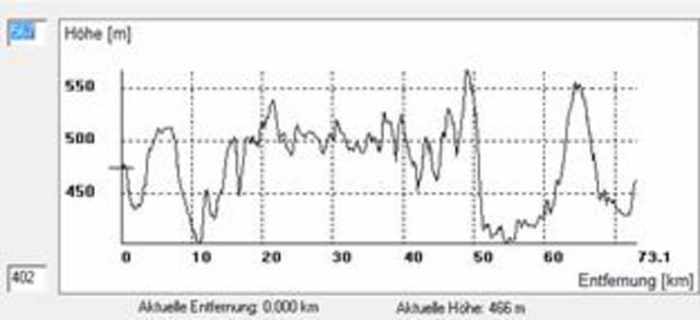
Aufzeichnung der Langdistanz der Nordschwabenrundfahrt 2009. Technisch sehr einfach mit ein paar harmlosen Trails in der zweiten hälfte, für die Gegend relativ viele Höhenmeter mit einem Anstieg von ca. 150hm am Stück. Während der Veranstaltung hätte ca. bei KM 20 und 55 eine Verpflegungsstelle gegeben.

Further information at

http://team-laura.de.s23565.evanzo-server.de/nsr/nsr06/index.php?option=com_frontpage&Itemid=1

Tour gallery

Tour map and elevation profile

  • Open Street Map
  • Google
Minimum height 99999 m Maximum height -99999 m Detailed view

More about the tour author

ralf_martin
Member since 2009

Send private message

Comments

mtbbee on 24.03.2012

wundervolle Frühjahrstour

danke für die Tour - Spaßfaktor würde ich höher setzen :-) - sehr gute Konditionstour. Mit Edge 800 sind wir auf 79km und 1185 hm gekommen

Absolute EMpfehlung für Marathonfahrer

Grüße
S+A
Start der Tour ist an der Turnhalle/Sportplatz von Bissingen im Kesseltal.

GPS tracks

Trackpoints
  • GPX / Garmin Map Source (gpx) download
  • TCX / Garmin Training Center® (tcx) download
  • CRS / Garmin Training Center® (crs) download
  • Google Earth (kml) download
  • G7ToWin (g7t) download
  • TTQV (trk) download
  • Overlay (ovl) download
  • Fugawi (txt) download
  • Kompass (DAV) Track (tk) download
  • Track data sheet (pdf) download
  • Original file of the author (gpx) download

More about the tour author

ralf_martin
Member since 2009

Send private message
Share track
Add to my favorites
Remove from my favorites
Edit tags
My score
Rate
Track: Nordschwabenrundfahrt 2009
Type: Mountain bike
Distance: 75,3 km
Evaluated on:
Duration:
Day(s)
Hour(s)
Minute(s)
Score: Landscape Fun factor Fitness Technique