


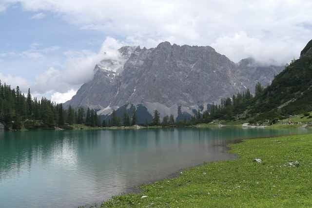
Vom Campingplatz Zugspitzarena hoch über Ehrwald auf dem Panoramaweg zur Talstation Ehrwalder Almbahn weiter auf der Fahrstraße bis zur Ehrwalder Alm, auf Schotter geht’s vorbei an der Seebenalm zum Seebensee bis zur Materialseilbahn Coburgerhütte (Hikertipp Aufstieg ca. 45min) . Auf dem gleichen Weg zurück bis ca. 2km unterhalb der Ehrwalder Alm rechts ein Forstweg abzweigt, hier bis Hinweisschild „Koppensteig“ fahren, jetzt folgen mehrere steile Schiebepassagen talwärts, bei der Wegkreuzung weiter dem Schild „Koppensteig“folgen wieder mehrere steile Schiebepassagen diesmal bergwärts, am Lähngraben fährt man entlang der Skipiste zum Höhenweg und vorbei an der Gamsalm zurück zum Ausgangspunkt.
Tour gallery
Tour map and elevation profile
Minimum height 316 m
Maximum height 1667 m
More about the tour author

|
bergkine |
Comments

sessionrider
on 10.05.2007
Landschaftlich vom Feinsten! Teilweise schwierige Trailpassagen.
München–Garmisch-Ehrwald nach der Brücke links zur Zugspitzbahn bis Campingplatz folgen.(Parkplatz)
GPS tracks
Trackpoints-
GPX / Garmin Map Source (gpx) download
-
TCX / Garmin Training Center® (tcx) download
-
CRS / Garmin Training Center® (crs) download
-
Google Earth (kml) download
-
G7ToWin (g7t) download
-
TTQV (trk) download
-
Overlay (ovl) download
-
Fugawi (txt) download
-
Kompass (DAV) Track (tk) download
-
Track data sheet (pdf) download
-
Original file of the author (g7t) download
More about the tour author
|
|
bergkine |
Add to my favorites
Remove from my favorites
Edit tags
Open track
My score
Rate