Login

Forgot your login?

Cookies have to be accepted!
Your browser's cookie functionality is disabled. Please enable this functionality.

Not a member yet?

Register now
Login

Available for registred users only

Log in to use this feature.

Forgot your login?

Cookies have to be accepted!
Your browser's cookie functionality is disabled. Please enable this functionality.

Not a member yet?

Register now
Filter
Categories
Advanced filters
  • Distance (km)
  • Height
Save filters Reset filter

TrackRank

QRCode

Technical data

Distance21,7 km Height1700 m Way down309 m Duration00:00 h:m Date08.09.2009
Scores Author Landscape Fun factor Fitness Technique

Statistics

526 Views Scores 64 Downloads Average
Rate
  • Track data sheet
  • Directions
  • Downloads

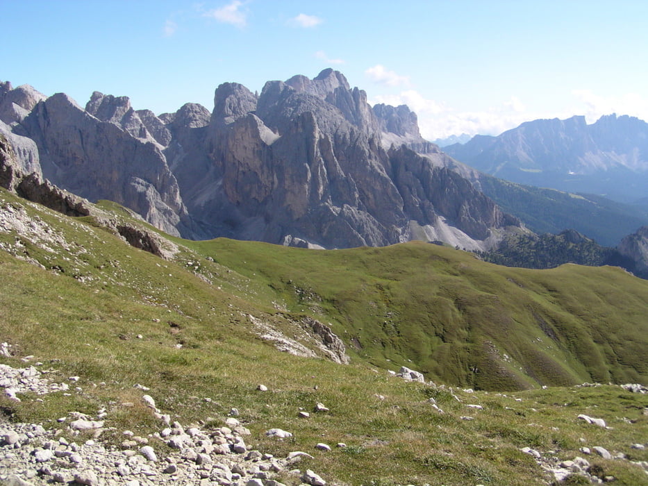
Meine Frau und ich sind von Tiers zur Bozener Schlernhaus gewandert.

Der Weg ging weiter leicht bis zu den Eselrücken. Und dann kommt ein Abstieg  + Aufstieg zur Hütte.

Ich war sehr Überrascht über die Eindrücke der Berge.


Bitte bestellt einen Schlafplatz für Euch in der Hütte

http://www.tierseralpl.com/

Tour gallery

Tour map and elevation profile

  • Open Street Map
  • Google
Minimum height 1044 m Maximum height 2560 m Detailed view

More about the tour author

julianernst
Member since 2007

Send private message

Comments

Mit den Bus von Bozen, oder mit dem Taxie kosten ca, 45 €


Der Nahverkehr ist sehr günstig in Südtirol

GPS tracks

Trackpoints
  • GPX / Garmin Map Source (gpx) download
  • TCX / Garmin Training Center® (tcx) download
  • CRS / Garmin Training Center® (crs) download
  • Google Earth (kml) download
  • G7ToWin (g7t) download
  • TTQV (trk) download
  • Overlay (ovl) download
  • Fugawi (txt) download
  • Kompass (DAV) Track (tk) download
  • Track data sheet (pdf) download
  • Original file of the author (gpx) download

More about the tour author

julianernst
Member since 2007

Send private message
Share track
Add to my favorites
Remove from my favorites
Edit tags
My score
Rate
Track: Tiers bis zur Tierser Hütte
Type: Hiking
Distance: 21,7 km
Evaluated on:
Duration:
Day(s)
Hour(s)
Minute(s)
Score: Landscape Fun factor Fitness Technique