Login

Forgot your login?

Cookies have to be accepted!
Your browser's cookie functionality is disabled. Please enable this functionality.

Not a member yet?

Register now
Login

Available for registred users only

Log in to use this feature.

Forgot your login?

Cookies have to be accepted!
Your browser's cookie functionality is disabled. Please enable this functionality.

Not a member yet?

Register now
Filter
Categories
Advanced filters
  • Distance (km)
  • Height
Save filters Reset filter

TrackRank

QRCode

Technical data

Distance32,4 km Height598 m Way down598 m Duration02:30 h:m Date28.09.2009
Scores Author User Landscape Fun factor Fitness Technique

Statistics

678 Views 3 Scores 173 Downloads 4.00 Average
Rate
  • Track data sheet
  • Directions
  • Downloads

Mountainbike-Tour

Sindelfingen - Magstadt - Warmbronn - Glemseck - Büsnau - Katzenbacher Hof - Sindelfingen

Tour überwiegend auf Wald-/Forstwegen und Single Trails

bei feuchtem Wetter stellenweise sehr schlammig mit wenig Ausweichmöglichkeiten

Versorgungsmöglichkeiten (Getränke+Essen) beim Katzenbacher Hof
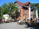
Tour gallery

Tour map and elevation profile

  • Open Street Map
  • Google
Minimum height 391 m Maximum height 541 m Detailed view

More about the tour author

Hatschi
Member since 2009

Send private message

Comments

Marksman on 20.07.2010

Tolle Tour mit schönen Trails

Bei bestem Wetter auf den wirklich schönen (und heute auch trockenen) Trails gesurft. Besten Dank für die Tour!

Start am Floschenstadion in Sindelfingen.

Hier gibt es auch Parkmöglichkeiten

GPS tracks

Trackpoints
  • GPX / Garmin Map Source (gpx) download
  • TCX / Garmin Training Center® (tcx) download
  • CRS / Garmin Training Center® (crs) download
  • Google Earth (kml) download
  • G7ToWin (g7t) download
  • TTQV (trk) download
  • Overlay (ovl) download
  • Fugawi (txt) download
  • Kompass (DAV) Track (tk) download
  • Track data sheet (pdf) download
  • Original file of the author (gpx) download

More about the tour author

Hatschi
Member since 2009

Send private message
Share track
Add to my favorites
Remove from my favorites
Edit tags
My score
Rate
Track: Kaba Challenge
Type: Mountain bike
Distance: 32,4 km
Evaluated on:
Duration:
Day(s)
Hour(s)
Minute(s)
Score: Landscape Fun factor Fitness Technique