


Nette, gerade Bergtour mit lohenendem Ziel
Auffahrt zur Bürndlingalm meist auf Forstwegautobahn, manchmal sogar geteert. Im Bereich über der Bergstation hochfrequentiert. Es lohnt sich ein paar meter weiter zu fahren und den Blick auf Alm und Chiemsee zu geniessen. Leider ist dann 80m über der Bründlingalm Schluss.
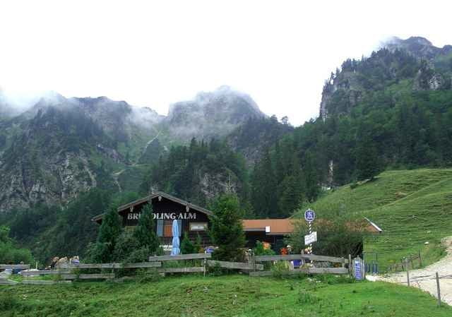
Einkehr: Bründlingalm ist wärmstens zu enmpfehlen! Wirt ist zwar ein Nordostlicht, aber schwer in Ordnung. Sehr sehr gute Brotzeitplatte (mit die beste Wertung der Region). Es kann halt viel los sein und günstig ist es nicht gerade.
Auffahrt zur Bürndlingalm meist auf Forstwegautobahn, manchmal sogar geteert. Im Bereich über der Bergstation hochfrequentiert. Es lohnt sich ein paar meter weiter zu fahren und den Blick auf Alm und Chiemsee zu geniessen. Leider ist dann 80m über der Bründlingalm Schluss.
Einkehr: Bründlingalm ist wärmstens zu enmpfehlen! Wirt ist zwar ein Nordostlicht, aber schwer in Ordnung. Sehr sehr gute Brotzeitplatte (mit die beste Wertung der Region). Es kann halt viel los sein und günstig ist es nicht gerade.
Further information at
http://www.martin-blum.de/bikeTour gallery
Tour map and elevation profile
Minimum height 583 m
Maximum height 1170 m
More about the tour author
|
|
martin.blum |
Comments
A8 München- Salzburg, Ausfahrt Bergen. In Bergen Parkplatz der Hochfellnbahn
GPS tracks
Trackpoints-
GPX / Garmin Map Source (gpx) download
-
TCX / Garmin Training Center® (tcx) download
-
CRS / Garmin Training Center® (crs) download
-
Google Earth (kml) download
-
G7ToWin (g7t) download
-
TTQV (trk) download
-
Overlay (ovl) download
-
Fugawi (txt) download
-
Kompass (DAV) Track (tk) download
-
Track data sheet (pdf) download
-
Original file of the author (gpx) download
More about the tour author
|
|
martin.blum |
Add to my favorites
Remove from my favorites
Edit tags
Open track
My score
Rate
hochfelln