


Die Tour folgt zu 70% den Ruhpoldinger MTB Marathon. Von Parkplatz in Seegatterl aus nach rechts Richtung Ruhpolding. Sehr schöne Strecke zum warm fahren, da es relativ flach ist. Vorbei am Biathlonzentrum (interessant zum anschaun)) weiter bis kurz vor Ruhpolding. Links halten und ab jetzt geht es stetig bergauf. Leider sind keine Singletrails dabei sondern nur Feldwege. Einen richtigen Gipfel haben wir nicht erreicht und fahren dann zur wunderschönen Röhrmoosalm (Vorsicht viele Wanderer) und einen schönen breiten Trail wieder hinunter zur Hauptstrasse, ab hier rechts von der Strasse halten und zurück zum Parkplatz. Wer am Ziel noch nicht genug hat kann noch eine Runde hinauf zur Winkelmoosalm fahren. Am grossen Parkplatz ganz hinten rechts den Weg hinauf (ca. 500hm) und Abfahrt über die geteerte Strasse links.
Mehr Infos und Touren auf www.bike-o-rama.de und www.hauzenberg.net
Further information at
http://www.bike-o-rama.deTour gallery
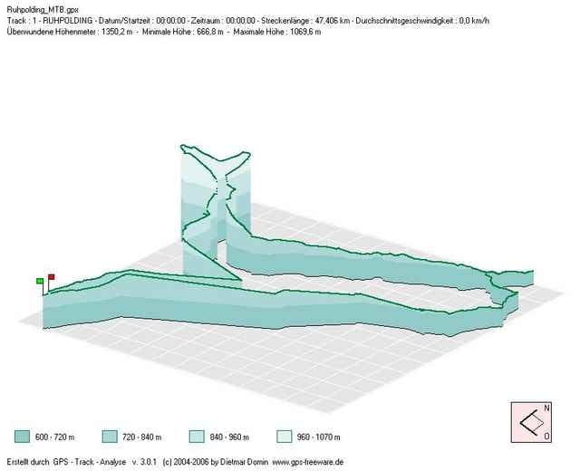
Tour map and elevation profile
Minimum height 667 m
Maximum height 1070 m
More about the tour author
|
|
spuxl |
Comments

Von der A8 München - Salzburg Abzweigung Übersee.
Weiter Richtung Unterwössen nach Reit im Winkel, der Beschilderung nach Ruhpolding folgen und am grossen Parkplatz in Seegatterl (Winkelmoosalm) parken.
Weiter Richtung Unterwössen nach Reit im Winkel, der Beschilderung nach Ruhpolding folgen und am grossen Parkplatz in Seegatterl (Winkelmoosalm) parken.
GPS tracks
Trackpoints-
GPX / Garmin Map Source (gpx) download
-
TCX / Garmin Training Center® (tcx) download
-
CRS / Garmin Training Center® (crs) download
-
Google Earth (kml) download
-
G7ToWin (g7t) download
-
TTQV (trk) download
-
Overlay (ovl) download
-
Fugawi (txt) download
-
Kompass (DAV) Track (tk) download
-
Track data sheet (pdf) download
-
Original file of the author (gpx) download
More about the tour author
|
|
spuxl |
Add to my favorites
Remove from my favorites
Edit tags
Open track
My score
Rate