


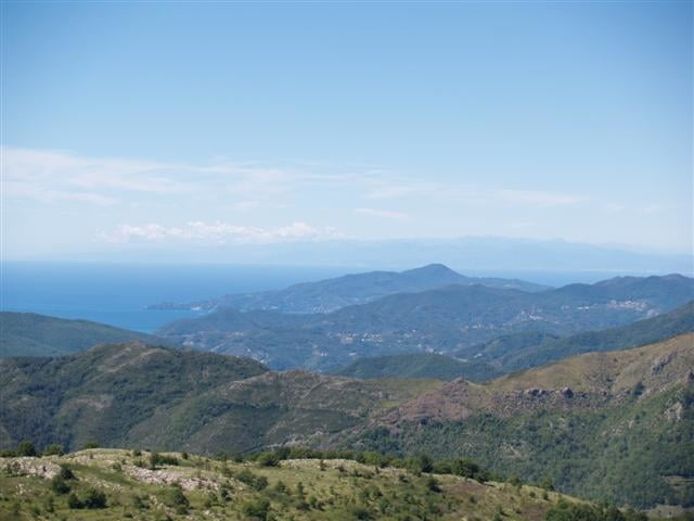
Start in Varese Ligure (eine von der EU zertifizierte "Öko-Gemeinde") in Richtung Passo della Biscia. Abzweigung nach Valletti nehmen. Dort hinter der Kirche dem Wanderweg folgen. Am Passo angekommen noch auf den Hügel hinter dem Denkmal hochfahren: Blick auf die gesamte ligurische Küste!
Wenn man das Ding andersrum fährt ist die Auffahrt komplett auf Asphalt und der Downhill auf der Forststrasse.
Wanderkarte 1:50000 gibt es in Varese Ligure gratis bei der Touri-Info.
Wenn man das Ding andersrum fährt ist die Auffahrt komplett auf Asphalt und der Downhill auf der Forststrasse.
Wanderkarte 1:50000 gibt es in Varese Ligure gratis bei der Touri-Info.
Further information at
http://www.liguriaplanet.com/web/eng/la_spezia/varese_ligure/varese_ligure.htmTour gallery
Tour map and elevation profile
Minimum height 348 m
Maximum height 954 m
More about the tour author

|
veste |
Comments
Autostrada A12 Genua-La Spezia exit: Sestri Levante => Route 523 => Varese Ligure.
GPS tracks
Trackpoints-
GPX / Garmin Map Source (gpx) download
-
TCX / Garmin Training Center® (tcx) download
-
CRS / Garmin Training Center® (crs) download
-
Google Earth (kml) download
-
G7ToWin (g7t) download
-
TTQV (trk) download
-
Overlay (ovl) download
-
Fugawi (txt) download
-
Kompass (DAV) Track (tk) download
-
Track data sheet (pdf) download
-
Original file of the author (gpx) download
More about the tour author
|
|
veste |
Add to my favorites
Remove from my favorites
Edit tags
Open track
My score
Rate
Schöne Tour
Find ich besser.
Tour kann dann verlängert werden.
In Valletti abbiegen und wieder hoch nach Colli Valetti und dann erst uber Piste und später auf Asphalt nach Ossegna (netter Ort) und Cembrano zurück nach Varese.