Login

Forgot your login?

Cookies have to be accepted!
Your browser's cookie functionality is disabled. Please enable this functionality.

Not a member yet?

Register now
Login

Available for registred users only

Log in to use this feature.

Forgot your login?

Cookies have to be accepted!
Your browser's cookie functionality is disabled. Please enable this functionality.

Not a member yet?

Register now
Filter
Categories
Advanced filters
  • Distance (km)
  • Height
Save filters Reset filter

TrackRank

QRCode

Technical data

Distance21,6 km Height1325 m Way down38 m Duration04:00 h:m Date26.09.2006
Scores Author Landscape Fun factor Fitness Technique

Statistics

4086 Views Scores 247 Downloads Average
Rate
  • Track data sheet
  • Directions
  • Downloads
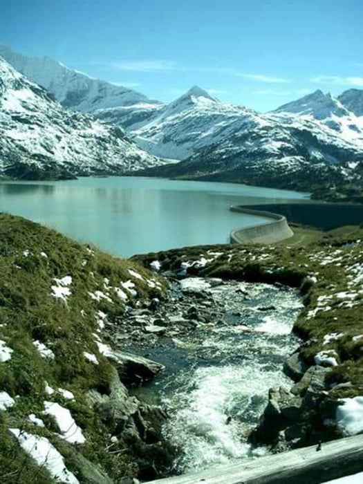
von Utendorf (Radwanderweg an der Salzach) zum Tauernmoossee über den Enzingerboden. Die Tauernmoossee-Staumauer ist eine der längsten geschwungenen Staumauern Europas.

Tour gallery

Tour map and elevation profile

  • Open Street Map
  • Google
Minimum height 779 m Maximum height 2104 m Detailed view

More about the tour author

Reichartz

Comments

Start and der Salzachbrücke (Radwanderweg) Richtung Enzingerboden.Kurz vor dem Enzingerboden geht es links (Schranke) zum Tauernmoossee. Achtung unbeleuchteter Tunnel!

GPS tracks

Trackpoints
  • GPX / Garmin Map Source (gpx) download
  • TCX / Garmin Training Center® (tcx) download
  • CRS / Garmin Training Center® (crs) download
  • Google Earth (kml) download
  • G7ToWin (g7t) download
  • TTQV (trk) download
  • Overlay (ovl) download
  • Fugawi (txt) download
  • Kompass (DAV) Track (tk) download
  • Track data sheet (pdf) download
  • Original file of the author (gpx) download

More about the tour author

Reichartz

Share track
Add to my favorites
Remove from my favorites
Edit tags
My score
Rate
Track: Tauernmoossee
Type: Mountain bike
Distance: 21,6 km
Evaluated on:
Duration:
Day(s)
Hour(s)
Minute(s)
Score: Landscape Fun factor Fitness Technique