


Die Route
Start/ Ziel: Südliche Seite der Theodor-Heuss-Brücke (=nördlich von Bismarckplatz)
Route: Philosophenweg - Oberer Philosophenweg - Brandplattenweg - Zollstockfussweg - Heiligenberg Gipfel/ Michaelskloster - Abfahrt Hainsbachfussweg - Biehler Fussweg - Schweizerweg
Kurzbeschreibung
Die Runde ist sehr abwechslungsreich und tauglich für den Feierabend zum Auspowern, daher maximaler Spaßfaktor. Landschaftlich hat man je nach Jahreszeit wundervolle Blicke über Heidelberg; insbesondere die Aussichtshütte am Brandplattenweg gibt hier einiges her, auch lohnt sich ein Blick vom Turm des Michaelsklosters. Konditionell bekommt die Runde aufgrund ihrer Kürze nur zwei Sterne, jedoch sind die Wege bergauf anspruchsvoll zu fahren (Waldboden, Wurzeln, Steine). Bergab wird's zunächst flowig auf Single-Trails, dann anspruchsvoller aufgrund von Serpentinen und kleineren Stufen.
Fazit
Eine geniale Minirunde über den Heiligenberg mit hohem Single-Trail-Anteil, bergauf und bergab.
Tour gallery
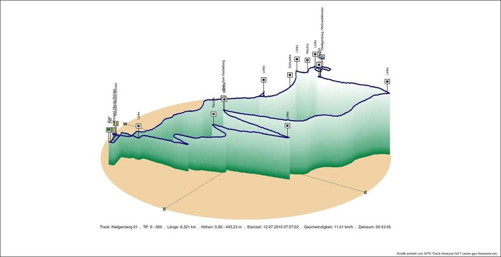
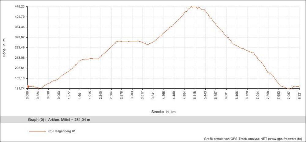
Tour map and elevation profile
Minimum height 122 m
Maximum height 445 m
More about the tour author
|
|
DerFloh |
Comments

Start/ Ziel: Südliche Seite der Theodor-Heuss-Brücke (=nördlich von Bismarckplatz), Heidelberg
GPS tracks
Trackpoints-
GPX / Garmin Map Source (gpx) download
-
TCX / Garmin Training Center® (tcx) download
-
CRS / Garmin Training Center® (crs) download
-
Google Earth (kml) download
-
G7ToWin (g7t) download
-
TTQV (trk) download
-
Overlay (ovl) download
-
Fugawi (txt) download
-
Kompass (DAV) Track (tk) download
-
Track data sheet (pdf) download
-
Original file of the author (gpx) download
More about the tour author
|
|
DerFloh |
Add to my favorites
Remove from my favorites
Edit tags
Open track
My score
Rate