


Stehts dem GPS Track folgen.
ca. 80% der Strecke sind Feldwege und Pfade
Ortsdurchfahrten: Halle/ Saale, Tornau, Oppin, Petersberg, Priester, Sybitz, Gimritz, Wettin(Saalfähre), Zaschwitz, Fienstedt, Naundorf, Räther, Höhnstedt, Langenbogen, Kölme, Bennstedt, Halle/ Saale
ca. 80% der Strecke sind Feldwege und Pfade
Ortsdurchfahrten: Halle/ Saale, Tornau, Oppin, Petersberg, Priester, Sybitz, Gimritz, Wettin(Saalfähre), Zaschwitz, Fienstedt, Naundorf, Räther, Höhnstedt, Langenbogen, Kölme, Bennstedt, Halle/ Saale
Further information at
http://www.bike-insider.deTour gallery
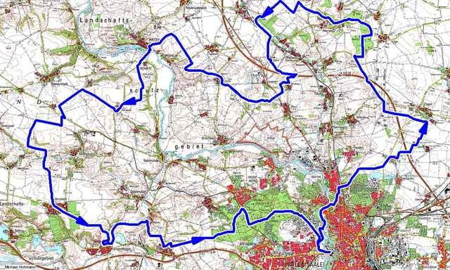
Tour map and elevation profile
Minimum height 66 m
Maximum height 222 m
More about the tour author
|
|
hummel |
Comments

per Bahn: Halle/S Hbf, dann TRAM Ri.Göttinger Bogen/Heide Hst. Saline
per PKW: Ri. Zentrum-Saline
(genügend kostenlose Parkplätze in der Nähe)
per PKW: Ri. Zentrum-Saline
(genügend kostenlose Parkplätze in der Nähe)
GPS tracks
Trackpoints-
GPX / Garmin Map Source (gpx) download
-
TCX / Garmin Training Center® (tcx) download
-
CRS / Garmin Training Center® (crs) download
-
Google Earth (kml) download
-
G7ToWin (g7t) download
-
TTQV (trk) download
-
Overlay (ovl) download
-
Fugawi (txt) download
-
Kompass (DAV) Track (tk) download
-
Track data sheet (pdf) download
-
Original file of the author (gpx) download
More about the tour author
|
|
hummel |
Add to my favorites
Remove from my favorites
Edit tags
Open track
My score
Rate