


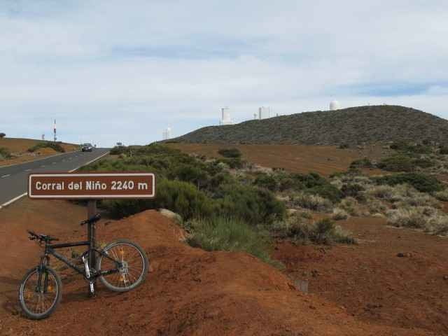
Die Tour fuehrt hauptsaechlich auf der Strasse (TF21) bis zum Observatorium del Teide. Ausgehend von Puerto de la Cruz geht es ueber La Orotava auf die Hautpstrasse TF21. Diese fuehrt mit moderaten 3-5% Steigung vorbei an Aguamasa bis auf 1600hm. Beim Rastplatz "Rodriguez" kann man links in den Wald einfahren. Der Off-Road Teil der Strecke verlaeuft bis ca. 2000hm im Wald. Oberhalb der Baumgrenze eroeffnet sich dann eine wunderbare, karge Landschaft. Bei ca. 2340hm muendet der Weg beim "Corral del Niño" in die TF-24. Von dort ist das Observatorium schoen zu sehen. Aus Zeitgruenden habe ich die Abfahrt komplett auf der Strasse absolviert.
ACHTUNG: Die letzte Versorgungsmoeglichkeit gibt es auf ca. 800hm, danach ist man auf sich selbst gestellt. Ab 2000hm wird es deutlich anstrengender.
ACHTUNG: Die letzte Versorgungsmoeglichkeit gibt es auf ca. 800hm, danach ist man auf sich selbst gestellt. Ab 2000hm wird es deutlich anstrengender.
Further information at
http://www.fatalmind.com/private/200702-Tenerife/ObservatoryTour.htmlTour gallery
Tour map and elevation profile
Minimum height 18 m
Maximum height 2411 m
More about the tour author

|
fatalmind |
Comments

Puerto de la Cruz - La Orotava - Aguamasa - Wald - Corral del Niño.
GPS tracks
Trackpoints-
GPX / Garmin Map Source (gpx) download
-
TCX / Garmin Training Center® (tcx) download
-
CRS / Garmin Training Center® (crs) download
-
Google Earth (kml) download
-
G7ToWin (g7t) download
-
TTQV (trk) download
-
Overlay (ovl) download
-
Fugawi (txt) download
-
Kompass (DAV) Track (tk) download
-
Track data sheet (pdf) download
-
Original file of the author (gpx) download
More about the tour author
|
|
fatalmind |
Add to my favorites
Remove from my favorites
Edit tags
Open track
My score
Rate